
Spenden
Rüsten Sie sich für Ihr nächstes Abenteuer:
Als Amazon-Partner erhält diese Website eine Provision für qualifizierte Käufe, ohne zusätzliche Kosten für Sie.
Topografische Karte Wansfell Pike
Klicken Sie auf die Karte, um die Höhe anzuzeigen.
Spenden
Rüsten Sie sich für Ihr nächstes Abenteuer:
Als Amazon-Partner erhält diese Website eine Provision für qualifizierte Käufe, ohne zusätzliche Kosten für Sie.
Wansfell Pike
Wansfell has an extensive summit ridge with two tops. The highest point of the fell is called Baystones with a height of 488 m (1,601 ft), while Wansfell Pike, which lies a kilometre to the south west reaches an elevation of 482 m (1,581 ft). Of the two summits, Wansfell Pike is regarded as the “true” summit of the fell by many fell walkers because of its superior view, even though it is the lower of the pair.
Spenden
Rüsten Sie sich für Ihr nächstes Abenteuer:
Als Amazon-Partner erhält diese Website eine Provision für qualifizierte Käufe, ohne zusätzliche Kosten für Sie.
Über diese Karte
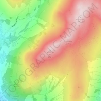
Name: Topografische Karte Wansfell Pike, Höhe, Relief.
Durchschnittliche Höhe: 285 m
Minimale Höhe: 53 m
Maximale Höhe: 484 m
Spenden
Rüsten Sie sich für Ihr nächstes Abenteuer:
Als Amazon-Partner erhält diese Website eine Provision für qualifizierte Käufe, ohne zusätzliche Kosten für Sie.
Andere topografische Karten
Klicken Sie auf eine Karte, um ihre Topografie, ihre Höhe und ihr Relief anzuzeigen.
Dovenest Wood
United Kingdom > England > Westmorland and Furness > Ambleside
Durchschnittliche Höhe: 134 m