
Topografische Karte Bethesda
Interaktive Karte
Klicken Sie auf die Karte, um die Höhe anzuzeigen.
Über diese Karte
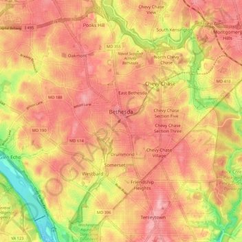
Name: Topografische Karte Bethesda, Höhe, Relief.
Ort: Bethesda, Montgomery County, Maryland, États-Unis d'Amérique (38.94040 -77.15856 39.02242 -77.07716)
Durchschnittliche Höhe: 86 m
Minimale Höhe: 4 m
Maximale Höhe: 129 m
Andere topografische Karten
Klicken Sie auf eine Karte, um ihre Topografie, ihre Höhe und ihr Relief anzuzeigen.
Gaithersburg
États-Unis d'Amérique > Maryland > Montgomery County > Gaithersburg
Gaithersburg, Montgomery County, Maryland, États-Unis d'Amérique
Durchschnittliche Höhe: 137 m
Takoma Park
États-Unis d'Amérique > Maryland > Montgomery County
Takoma Park, Montgomery County, Maryland, 20912, États-Unis d'Amérique
Durchschnittliche Höhe: 75 m