
Topografische Karte Houston
Interaktive Karte
Klicken Sie auf die Karte, um die Höhe anzuzeigen.
Über diese Karte
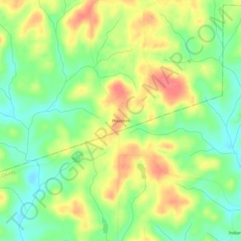
Name: Topografische Karte Houston, Höhe, Relief.
Ort: Houston, Heard County, Georgia, 30219, United States (33.13957 -85.15772 33.17957 -85.11772)
Durchschnittliche Höhe: 229 m
Minimale Höhe: 198 m
Maximale Höhe: 264 m
Andere topografische Karten
Klicken Sie auf eine Karte, um ihre Topografie, ihre Höhe und ihr Relief anzuzeigen.
Glenn
United States > Georgia > Heard County
Glenn, Heard County, Georgia, United States
Durchschnittliche Höhe: 239 m
Cooksville
United States > Georgia > Heard County
Cooksville, Heard County, Georgia, United States
Durchschnittliche Höhe: 212 m
Glenloch
United States > Georgia > Heard County
Glenloch, Heard County, Georgia, United States
Durchschnittliche Höhe: 289 m
Roosterville
United States > Georgia > Heard County
Roosterville, Heard County, Georgia, 30170, United States
Durchschnittliche Höhe: 302 m
Viola
United States > Georgia > Heard County
Viola, Heard County, Georgia, United States
Durchschnittliche Höhe: 237 m
Owensbyville
United States > Georgia > Heard County
Owensbyville, Heard County, Georgia, United States
Durchschnittliche Höhe: 214 m
Centralhatchee
United States > Georgia > Heard County
Centralhatchee, Heard County, Georgia, United States
Durchschnittliche Höhe: 252 m
Texas
United States > Georgia > Heard County
Texas, Heard County, Georgia, United States
Durchschnittliche Höhe: 258 m
Yellow Dirt
United States > Georgia > Heard County
Yellow Dirt, Heard County, Georgia, United States
Durchschnittliche Höhe: 237 m
Franklin
United States > Georgia > Heard County
Franklin, Heard County, Georgia, United States
Durchschnittliche Höhe: 223 m
Ephesus
United States > Georgia > Heard County
Ephesus, Heard County, Georgia, United States
Durchschnittliche Höhe: 360 m
Corinth
United States > Georgia > Heard County
Corinth, Heard County, Georgia, United States
Durchschnittliche Höhe: 233 m