
Topografische Karte Tagburos
Interaktive Karte
Klicken Sie auf die Karte, um die Höhe anzuzeigen.
Über diese Karte
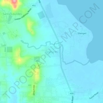
Name: Topografische Karte Tagburos, Höhe, Relief.
Ort: Tagburos, Puerto Princesa, Mimaropa, Philippines (9.79985 118.72097 9.83985 118.76097)
Durchschnittliche Höhe: 16 m
Minimale Höhe: -2 m
Maximale Höhe: 127 m
Andere topografische Karten
Klicken Sie auf eine Karte, um ihre Topografie, ihre Höhe und ihr Relief anzuzeigen.
Matahimik
Matahimik, Puerto Princesa, Mimaropa, 5300, Philippines
Durchschnittliche Höhe: 2 m
San Manuel
San Manuel, Puerto Princesa, Mimaropa, 5300, Philippines
Durchschnittliche Höhe: 9 m
Cabayugan
Cabayugan, Puerto Princesa, Mimaropa, Philippines
Durchschnittliche Höhe: 127 m
Karsoglan Hill
Karsoglan Hill, Puerto Princesa, Mimaropa, Philippines
Durchschnittliche Höhe: 150 m
Cleopatra Needle
Cleopatra Needle, Puerto Princesa, Mimaropa, Philippines
Durchschnittliche Höhe: 1.014 m
Maningning
Maningning, Puerto Princesa, Mimaropa, Philippines
Durchschnittliche Höhe: 8 m
Bancao-Bancao
Philippines > Puerto Princesa > Bancao-Bancao
Bancao-Bancao, Puerto Princesa, Mimaropa, Philippines
Durchschnittliche Höhe: 6 m