
Spenden
Rüsten Sie sich für Ihr nächstes Abenteuer:
Als Amazon-Partner erhält diese Website eine Provision für qualifizierte Käufe, ohne zusätzliche Kosten für Sie.
Topografische Karte Eckert
Klicken Sie auf die Karte, um die Höhe anzuzeigen.
Spenden
Rüsten Sie sich für Ihr nächstes Abenteuer:
Als Amazon-Partner erhält diese Website eine Provision für qualifizierte Käufe, ohne zusätzliche Kosten für Sie.
Über diese Karte
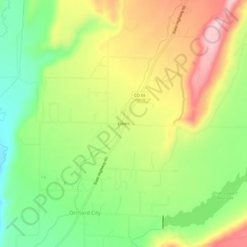
Name: Topografische Karte Eckert, Höhe, Relief.
Ort: Eckert, Delta County, Colorado, 81418, United States (38.82276 -107.98284 38.86276 -107.94284)
Durchschnittliche Höhe: 1.691 m
Minimale Höhe: 1.585 m
Maximale Höhe: 1.817 m
Spenden
Rüsten Sie sich für Ihr nächstes Abenteuer:
Als Amazon-Partner erhält diese Website eine Provision für qualifizierte Käufe, ohne zusätzliche Kosten für Sie.
Andere topografische Karten
Klicken Sie auf eine Karte, um ihre Topografie, ihre Höhe und ihr Relief anzuzeigen.
Cedaredge
United States > Colorado > Delta County
Located in a protected valley at 6,100 feet (1,900 m) in elevation, the Cedaredge Golf Club course has natural cedars and winding creek beds.
Durchschnittliche Höhe: 1.883 m
Cedaredge
United States > Colorado > Delta County
Located in a protected valley at 6,100 feet (1,900 m) in elevation, the Cedaredge Golf Club course has natural cedars and winding creek beds.
Durchschnittliche Höhe: 1.883 m
Cedaredge
United States > Colorado > Delta County
Located in a protected valley at 6,100 feet (1,900 m) in elevation, the Cedaredge Golf Club course has natural cedars and winding creek beds.
Durchschnittliche Höhe: 1.883 m
Spenden
Rüsten Sie sich für Ihr nächstes Abenteuer:
Als Amazon-Partner erhält diese Website eine Provision für qualifizierte Käufe, ohne zusätzliche Kosten für Sie.