
Topografische Karte Waterton Lakes National Park
Interaktive Karte
Klicken Sie auf die Karte, um die Höhe anzuzeigen.
Über diese Karte
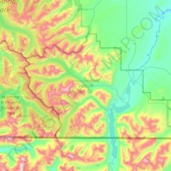
Name: Topografische Karte Waterton Lakes National Park, Höhe, Relief.
Durchschnittliche Höhe: 1.778 m
Minimale Höhe: 1.214 m
Maximale Höhe: 3.030 m
Operated by Parks Canada, Waterton is open all year, but the main tourist season is during July and August. The only commercial facilities available within the park are located at the Waterton Park townsite. This park ranges in elevation from 1,290 metres (4,232 ft) at the townsite to 2,910 m (9,547 ft) at Mount Blakiston. It offers many scenic trails, including Crypt Lake trail. In 2012/2013, Waterton Lakes National Park had 402,542 visitors.
Andere topografische Karten
Klicken Sie auf eine Karte, um ihre Topografie, ihre Höhe und ihr Relief anzuzeigen.
Mount Blakiston
Canada > Alberta > Improvement District No. 04
Mount Blakiston, Improvement District No. 04, Alberta, Canada
Durchschnittliche Höhe: 2.328 m
Waterton Park
Canada > Alberta > Improvement District No. 04
Waterton Park, Improvement District No. 04, Alberta, T0K 2M0, Canada
Durchschnittliche Höhe: 1.456 m