
Topografische Karte Bouxières-aux-Dames
Interaktive Karte
Klicken Sie auf die Karte, um die Höhe anzuzeigen.
Über diese Karte
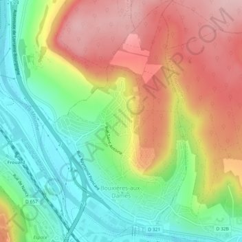
Name: Topografische Karte Bouxières-aux-Dames, Höhe, Relief.
Durchschnittliche Höhe: 271 m
Minimale Höhe: 181 m
Maximale Höhe: 372 m
Andere topografische Karten
Klicken Sie auf eine Karte, um ihre Topografie, ihre Höhe und ihr Relief anzuzeigen.
Saint-Martin
France > Grand Est > Meurthe-et-Moselle
Saint-Martin, Lunéville, Meurthe-et-Moselle, Grand Est, Metropolitan France, 54450, France
Durchschnittliche Höhe: 262 m
Courcelles
France > Grand Est > Meurthe-et-Moselle
Courcelles, Toul, Meurthe-et-Moselle, Grand Est, Metropolitan France, 54930, France
Durchschnittliche Höhe: 338 m
Belleville
France > Grand Est > Meurthe-et-Moselle
Belleville, Nancy, Meurthe-et-Moselle, Grand Est, Metropolitan France, 54940, France
Durchschnittliche Höhe: 236 m