
Topografische Karte Keith
Interaktive Karte
Klicken Sie auf die Karte, um die Höhe anzuzeigen.
Über diese Karte
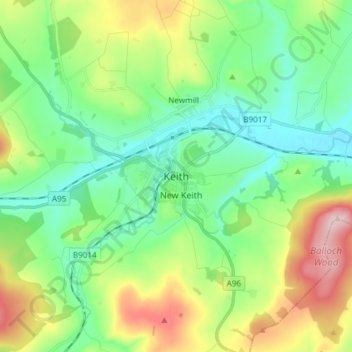
Name: Topografische Karte Keith, Höhe, Relief.
Ort: Keith, Moray, Scotland, AB55 5FF, United Kingdom (57.50273 -2.99233 57.58273 -2.91233)
Durchschnittliche Höhe: 180 m
Minimale Höhe: 96 m
Maximale Höhe: 364 m
Andere topografische Karten
Klicken Sie auf eine Karte, um ihre Topografie, ihre Höhe und ihr Relief anzuzeigen.
Lossiemouth
United Kingdom > Scotland > Moray
Lossiemouth, Moray, Scotland, IV31 6NU, United Kingdom
Durchschnittliche Höhe: 3 m
Findhorn Ecovillage
United Kingdom > Scotland > Moray > Findhorn > Findhorn Ecovillage
Findhorn Ecovillage, Findhorn, Moray, Scotland, IV36 3TZ, United Kingdom
Durchschnittliche Höhe: 3 m
Forres
United Kingdom > Scotland > Moray > Forres
Forres, Moray, Scotland, IV36 1NX, United Kingdom
Durchschnittliche Höhe: 31 m