
Topografische Karte Robins Air Force Base
Interaktive Karte
Klicken Sie auf die Karte, um die Höhe anzuzeigen.
Über diese Karte
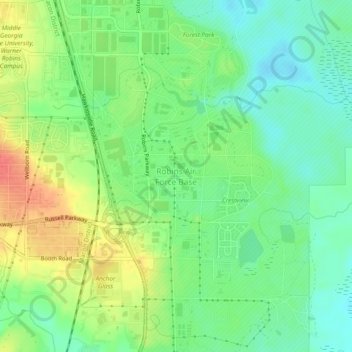
Name: Topografische Karte Robins Air Force Base, Höhe, Relief.
Durchschnittliche Höhe: 92 m
Minimale Höhe: 69 m
Maximale Höhe: 126 m
Andere topografische Karten
Klicken Sie auf eine Karte, um ihre Topografie, ihre Höhe und ihr Relief anzuzeigen.
Warner Robins
United States > Georgia > Houston County
Warner Robins, Houston County, Georgia, United States
Durchschnittliche Höhe: 101 m
Centerville
United States > Georgia > Houston County
Centerville, Houston County, Georgia, 31028, United States
Durchschnittliche Höhe: 136 m
Perry
United States > Georgia > Houston County
Perry, Houston County, Georgia, 31069, United States
Durchschnittliche Höhe: 111 m
Bonaire
United States > Georgia > Houston County
Bonaire, Houston County, Georgia, 31005, United States
Durchschnittliche Höhe: 100 m
Warner Robins
United States > Georgia > Houston County > Warner Robins
Warner Robins, Houston County, Georgia, 31098, United States
Durchschnittliche Höhe: 109 m