
Topografische Karte Carmo de Minas
Interaktive Karte
Klicken Sie auf die Karte, um die Höhe anzuzeigen.
Über diese Karte
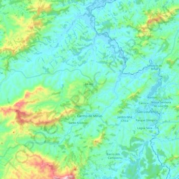
Name: Topografische Karte Carmo de Minas, Höhe, Relief.
Durchschnittliche Höhe: 1.004 m
Minimale Höhe: 853 m
Maximale Höhe: 1.658 m
Andere topografische Karten
Klicken Sie auf eine Karte, um ihre Topografie, ihre Höhe und ihr Relief anzuzeigen.
Lagoa dos Ingleses
Brazil > Minas Gerais > Região Metropolitana de Belo Horizonte > Nova Lima
Durchschnittliche Höhe: 1.335 m
Pico das Agulhas Negras
Brazil > Minas Gerais > Bocaina de Minas
A mountain shelter called Abrigo Rebouças is located near the base of the peak, at an elevation of about 2,350 metres (7,710 ft). It is accessible by a gravel road (BR-485) from the BR-354 federal highway at the Garganta do Registro mountain pass, via Itatiaia National Park's north entrance. The access road…
Durchschnittliche Höhe: 2.454 m
São Francisco de Assis
Brazil > Minas Gerais > Região Metropolitana de Belo Horizonte > Lagoa Santa
Durchschnittliche Höhe: 754 m
Belo Horizonte
Brazil > Minas Gerais > Região Metropolitana de Belo Horizonte
In 1893, due to the climatic and topographic conditions, Curral Del Rey was selected by Minas Gerais governor Afonso Pena among other cities as the location for the new economic and cultural center of the state, under the new name of Cidade de Minas, or City of Minas.
Durchschnittliche Höhe: 904 m
Pampulha
Brazil > Minas Gerais > Região Metropolitana de Belo Horizonte > Belo Horizonte > Pampulha
Durchschnittliche Höhe: 826 m
Itajubá
Brazil > Minas Gerais > Itajubá > Itajubá
Itajubá is a municipality in southeastern Minas Gerais state of the Federative Republic of Brazil. It lies in a valley by the Sapucaí river and has terrain elevations ranging from 827 to 1500 metres, occupying an area of 290.45 km2 (112.14 mi2), with a population of 97,334 people (2020 est). Neighboring the…
Durchschnittliche Höhe: 923 m
Bambuí
Brazil > Minas Gerais > Bambuí > Bambuí
The city center of Bambuí is located at an elevation of 706 meters on a plateau and straddles the 20th parallel. Neighboring municipalities are: Tapiraí and Córrego Danta (N), Luz (NE), Iguatama (E), Doresópolis (SE), Piumhi (S), São Roque de Minas and Medeiros (W).
Durchschnittliche Höhe: 708 m
Contagem
Brazil > Minas Gerais > Região Metropolitana de Belo Horizonte > Contagem
The city belongs to the metropolitan mesoregion and to the microregion of Belo Horizonte, has a territorial extension of 195.2 square kilometres (75.4 square miles), and borders the municipalities of Ribeirão das Neves, Esmeraldas, Betim, Ibirité and Belo Horizonte. The elevation of the city hall is 939…
Durchschnittliche Höhe: 890 m