
Topografische Karte Chalandri
Interaktive Karte
Klicken Sie auf die Karte, um die Höhe anzuzeigen.
Über diese Karte
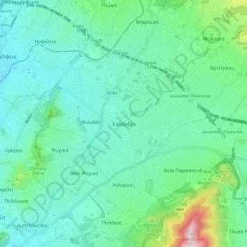
Name: Topografische Karte Chalandri, Höhe, Relief.
Durchschnittliche Höhe: 222 m
Minimale Höhe: 110 m
Maximale Höhe: 685 m
Andere topografische Karten
Klicken Sie auf eine Karte, um ihre Topografie, ihre Höhe und ihr Relief anzuzeigen.
Municipal Unit of Neo Psychiko
Greece > Attica > Regional Unit of North Athens
Municipal Unit of Neo Psychiko, Municipality of Filothei - Psychiko, Regional Unit of North Athens, Attica, 154 51, Greece
Durchschnittliche Höhe: 191 m
Marousi
Greece > Attica > Regional Unit of North Athens
Marousi, Municipality of Marousi, Regional Unit of North Athens, Attica, 151 24, Greece
Durchschnittliche Höhe: 257 m
Penteli Municipal Unit
Greece > Attica > Regional Unit of North Athens
Penteli Municipal Unit, Municipality of Penteli, Regional Unit of North Athens, Attica, 152 36, Greece
Durchschnittliche Höhe: 422 m
Olympus
Greece > Attica > Regional Unit of North Athens > Municipal Unit of Psychiko
Olympus, Municipal Unit of Psychiko, Municipality of Filothei - Psychiko, Regional Unit of North Athens, Attica, 154 52, Greece
Durchschnittliche Höhe: 204 m
Municipality of Marousi
Greece > Attica > Regional Unit of North Athens
Municipality of Marousi, Regional Unit of North Athens, Attica, Greece
Durchschnittliche Höhe: 224 m
Municipality of Metamorfosi
Greece > Attica > Regional Unit of North Athens
Municipality of Metamorfosi, Regional Unit of North Athens, Attica, Greece
Durchschnittliche Höhe: 174 m
Nea Penteli Municipal Unit
Greece > Attica > Regional Unit of North Athens > Nea Penteli Municipal Unit
Nea Penteli Municipal Unit, Municipality of Penteli, Regional Unit of North Athens, Attica, Greece
Durchschnittliche Höhe: 496 m
Municipality of Chalandri
Greece > Attica > Regional Unit of North Athens > Municipality of Chalandri
Municipality of Chalandri, Regional Unit of North Athens, Attica, Greece
Durchschnittliche Höhe: 208 m
Municipality of Kifisia
Greece > Attica > Regional Unit of North Athens
Municipality of Kifisia, Regional Unit of North Athens, Attica, Greece
Durchschnittliche Höhe: 342 m