
Topografische Karte Réville
Interaktive Karte
Klicken Sie auf die Karte, um die Höhe anzuzeigen.
Über diese Karte
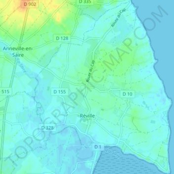
Name: Topografische Karte Réville, Höhe, Relief.
Durchschnittliche Höhe: 5 m
Minimale Höhe: -2 m
Maximale Höhe: 29 m
Andere topografische Karten
Klicken Sie auf eine Karte, um ihre Topografie, ihre Höhe und ihr Relief anzuzeigen.
Le Hameau Craville
France > Normandie > Manche > Teurthéville-Hague
Le Hameau Craville, Teurthéville-Hague, Cherbourg, Manche, Normandie, France métropolitaine, 50690, France
Durchschnittliche Höhe: 85 m
Hamel de Bas
France > Normandie > Manche > Carentan-les-Marais > Les Veys
Hamel de Bas, Les Veys, Carentan-les-Marais, Saint-Lô, Manche, Normandie, France métropolitaine, 50500, France
Durchschnittliche Höhe: 13 m
Buais-Les-Monts
France > Normandie > Manche > Buais-Les-Monts
Buais-Les-Monts, Avranches, Manche, Normandie, France métropolitaine, 50640, France
Durchschnittliche Höhe: 183 m
Montmartin-sur-Mer
France > Normandie > Manche > Montmartin-sur-Mer
Montmartin-sur-Mer, Coutances, Manche, Normandie, France métropolitaine, 50590, France
Durchschnittliche Höhe: 31 m