
Topografische Karte Leeds and Grenville
Interaktive Karte
Klicken Sie auf die Karte, um die Höhe anzuzeigen.
Über diese Karte
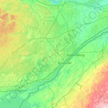
Name: Topografische Karte Leeds and Grenville, Höhe, Relief.
Durchschnittliche Höhe: 146 m
Minimale Höhe: 50 m
Maximale Höhe: 704 m
Andere topografische Karten
Klicken Sie auf eine Karte, um ihre Topografie, ihre Höhe und ihr Relief anzuzeigen.
Oxford Mills
Canada > Ontario > Leeds and Grenville Counties > North Grenville
Oxford Mills, North Grenville, Leeds and Grenville Counties, Est de l'Ontario, Ontario, K0G 1S0, Canada
Durchschnittliche Höhe: 103 m
Rideau River
Canada > Ontario > Leeds and Grenville Counties > Merrickville > Merrickville-Wolford
Rideau River, Rideau-Jock, Merrickville, Merrickville-Wolford, Leeds and Grenville Counties, Est de l'Ontario, Ontario, Canada
Durchschnittliche Höhe: 109 m
Jasper
Canada > Ontario > Leeds and Grenville Counties > Jasper
Jasper, Merrickville-Wolford, Leeds and Grenville Counties, Est de l'Ontario, Ontario, K0G 1G0, Canada
Durchschnittliche Höhe: 109 m