
Topografische Karte Talamet
Interaktive Karte
Klicken Sie auf die Karte, um die Höhe anzuzeigen.
Über diese Karte
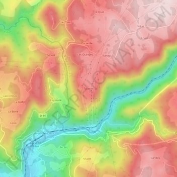
Name: Topografische Karte Talamet, Höhe, Relief.
Durchschnittliche Höhe: 401 m
Minimale Höhe: 159 m
Maximale Höhe: 571 m
Andere topografische Karten
Klicken Sie auf eine Karte, um ihre Topografie, ihre Höhe und ihr Relief anzuzeigen.
Saint-Mathurin Léobazel
France > Nouvelle-Aquitaine > Corrèze > Camps-Saint-Mathurin-Léobazel > Saint-Mathurin Léobazel
Saint-Mathurin Léobazel, Camps-Saint-Mathurin-Léobazel, Tulle, Corrèze, Nouvelle-Aquitaine, France métropolitaine, 19430, France
Durchschnittliche Höhe: 542 m
Camps
France > Nouvelle-Aquitaine > Corrèze > Camps-Saint-Mathurin-Léobazel > Camps
Camps, Camps-Saint-Mathurin-Léobazel, Tulle, Corrèze, Nouvelle-Aquitaine, France métropolitaine, 19430, France
Durchschnittliche Höhe: 505 m
Vidal
France > Nouvelle-Aquitaine > Corrèze > Camps-Saint-Mathurin-Léobazel > Camps
Vidal, Camps, Camps-Saint-Mathurin-Léobazel, Tulle, Corrèze, Nouvelle-Aquitaine, France métropolitaine, 19430, France
Durchschnittliche Höhe: 508 m
Le Ventoux
France > Nouvelle-Aquitaine > Corrèze > Camps-Saint-Mathurin-Léobazel
Le Ventoux, Camps-Saint-Mathurin-Léobazel, Tulle, Corrèze, Nouvelle-Aquitaine, France métropolitaine, 19430, France
Durchschnittliche Höhe: 549 m