
Topografische Karte Cozumel
Interaktive Karte
Klicken Sie auf die Karte, um die Höhe anzuzeigen.
Über diese Karte
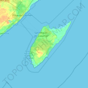
Name: Topografische Karte Cozumel, Höhe, Relief.
Ort: Cozumel, Quintana Roo, Mexico (20.27159 -87.36343 20.59771 -86.72395)
Durchschnittliche Höhe: 1 m
Minimale Höhe: -3 m
Maximale Höhe: 20 m
Large parts of the island are covered with mangrove forest which has many endemic animal species. Cozumel is a flat island based on limestone, resulting in a karst topography. The highest natural point on the island is less than 15 m (49 ft) above sea level. The cenotes are deep water-filled sinkholes formed by water percolating through the soft limestone soil for thousands of years. Cozumel's cenotes are restricted to qualified cave divers with appropriate credentials.
Andere topografische Karten
Klicken Sie auf eine Karte, um ihre Topografie, ihre Höhe und ihr Relief anzuzeigen.
Lázaro Cárdenas
Lázaro Cárdenas, Quintana Roo, Mexico
Durchschnittliche Höhe: 10 m
Isla Cozumel
Mexico > Quintana Roo > Cozumel
Isla Cozumel, Cozumel, Quintana Roo, Mexico
Durchschnittliche Höhe: 2 m
Cancún
Mexico > Quintana Roo > Benito Juárez
Cancún, Benito Juárez, Quintana Roo, Mexico
Durchschnittliche Höhe: 5 m
Isla Holbox
Isla Holbox, Lázaro Cárdenas, Quintana Roo, 77310, Mexico
Durchschnittliche Höhe: 1 m
Puerto Morelos
Mexico > Quintana Roo > Puerto Morelos
Puerto Morelos, Quintana Roo, Mexico
Durchschnittliche Höhe: 2 m
Isla Mujeres
Mexico > Quintana Roo > Municipio de Isla Mujeres
Isla Mujeres, Municipio de Isla Mujeres, Quintana Roo, Mexico
Durchschnittliche Höhe: 0 m
Playa del Carmen
Playa del Carmen, Solidaridad, Quintana Roo, Mexico
Durchschnittliche Höhe: 5 m
Cenote Mayan Blue
Mexico > Quintana Roo > Tulum
Cenote Mayan Blue, Tulum, Quintana Roo, Mexico
Durchschnittliche Höhe: 3 m
Yucatán Peninsula
Mexico > Quintana Roo > Othón P. Blanco
Yucatán Peninsula, Othón P. Blanco, Quintana Roo, Mexico
Durchschnittliche Höhe: 100 m
Pino Suárez
Mexico > Quintana Roo > Felipe Carrillo Puerto
Pino Suárez, Felipe Carrillo Puerto, Quintana Roo, Mexico
Durchschnittliche Höhe: 4 m
Lagos del Sol
Mexico > Quintana Roo > Benito Juárez
Lagos del Sol, Benito Juárez, Quintana Roo, 77569, Mexico
Durchschnittliche Höhe: 4 m
Bahia de Chetumal
Mexico > Quintana Roo > Othón P. Blanco
Bahia de Chetumal, Othón P. Blanco, Quintana Roo, Mexico
Durchschnittliche Höhe: 0 m
Tampak
Mexico > Quintana Roo > Felipe Carrillo Puerto
Tampak, Felipe Carrillo Puerto, Quintana Roo, Mexico
Durchschnittliche Höhe: 28 m
Isla Mujeres
Mexico > Quintana Roo > Isla Mujeres
Isla Mujeres, Municipio de Isla Mujeres, Quintana Roo, Mexico
Durchschnittliche Höhe: 0 m
Othón P. Blanco
Othón P. Blanco, Quintana Roo, Mexico
Durchschnittliche Höhe: 96 m
Chetumal
Mexico > Quintana Roo > Othón P. Blanco
Chetumal, Othón P. Blanco, Quintana Roo, Mexico
Durchschnittliche Höhe: 6 m
Macario Gómez
Mexico > Quintana Roo > Macario Gómez
Macario Gómez, Tulum, Quintana Roo, Mexico
Durchschnittliche Höhe: 17 m
San Miguel de Cozumel
Mexico > Quintana Roo > Cozumel
San Miguel de Cozumel, Cozumel, Quintana Roo, Mexico
Durchschnittliche Höhe: 3 m
San Juan de Dios
Mexico > Quintana Roo > San Juan de Dios
San Juan de Dios, Lázaro Cárdenas, Quintana Roo, Mexico
Durchschnittliche Höhe: 23 m
Holbox
Mexico > Quintana Roo > Holbox
Holbox, Lázaro Cárdenas, Quintana Roo, 77310, Mexico
Durchschnittliche Höhe: 0 m
Smz 25
Mexico > Quintana Roo > Cancún
Smz 25, Cancún, Benito Juárez, Quintana Roo, 77509, Mexico
Durchschnittliche Höhe: 7 m
Isla Mujeres
Mexico > Quintana Roo > Isla Mujeres
Isla Mujeres, Quintana Roo, Mexico
Durchschnittliche Höhe: 0 m