
Topografische Karte Alfred
Interaktive Karte
Klicken Sie auf die Karte, um die Höhe anzuzeigen.
Über diese Karte
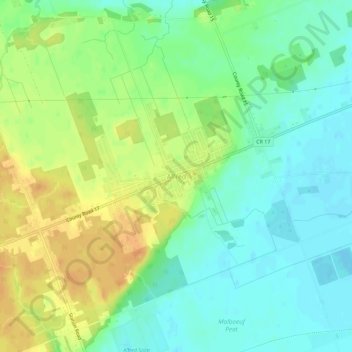
Name: Topografische Karte Alfred, Höhe, Relief.
Durchschnittliche Höhe: 64 m
Minimale Höhe: 49 m
Maximale Höhe: 84 m
Andere topografische Karten
Klicken Sie auf eine Karte, um ihre Topografie, ihre Höhe und ihr Relief anzuzeigen.
Lefaivre
Canada > Ontario > Prescott and Russell Counties > Alfred and Plantagenet
Lefaivre, Alfred and Plantagenet, Prescott and Russell Counties, Eastern Ontario, Ontario, K0B 1J0, Canada
Durchschnittliche Höhe: 50 m
Wendover
Canada > Ontario > Prescott and Russell Counties > Alfred and Plantagenet > Wendover
Wendover, Alfred and Plantagenet, Prescott and Russell Counties, Eastern Ontario, Ontario, K0A 3K0, Canada
Durchschnittliche Höhe: 49 m
Plantagenet
Canada > Ontario > Prescott and Russell Counties > Alfred and Plantagenet
Plantagenet, Alfred and Plantagenet, Prescott and Russell Counties, Eastern Ontario, Ontario, K0B 1L0, Canada
Durchschnittliche Höhe: 61 m