
Topografische Karte Utica
Interaktive Karte
Klicken Sie auf die Karte, um die Höhe anzuzeigen.
Über diese Karte
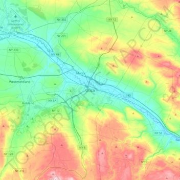
Name: Topografische Karte Utica, Höhe, Relief.
Durchschnittliche Höhe: 268 m
Minimale Höhe: 116 m
Maximale Höhe: 585 m
The city's Mohawk name, Unundadages ("around the hill") refers to a bend in the Mohawk River that flows around the city's elevated position as seen from the Deerfield Hills in the north. The Erie Canal and Mohawk River pass through northern Utica; northwest of downtown is the Utica Marsh, a group of cattail wetlands between the Erie Canal and Mohawk River (partially in the town of Marcy) with a variety of animals, plants and birds. During the 1850s, plank roads were built through the marshland surrounding the city. Utica's suburbs have more hills and cliffs than the city. Located where the Mohawk Valley forms a wide floodplain, the city has a generally sloping, flat topography.