
Topografische Karte Georgetown County
Interaktive Karte
Klicken Sie auf die Karte, um die Höhe anzuzeigen.
Über diese Karte
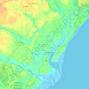
Name: Topografische Karte Georgetown County, Höhe, Relief.
Ort: Georgetown County, South Carolina, USA (33.09464 -79.68111 33.78017 -78.98482)
Durchschnittliche Höhe: 6 m
Minimale Höhe: -4 m
Maximale Höhe: 30 m
Andere topografische Karten
Klicken Sie auf eine Karte, um ihre Topografie, ihre Höhe und ihr Relief anzuzeigen.
Kiawah Island
USA > South Carolina > Kiawah Island
Kiawah Island, Charleston County, South Carolina, USA
Durchschnittliche Höhe: 2 m
Red Hill
USA > South Carolina > Red Hill
Red Hill, Horry County, South Carolina, USA
Durchschnittliche Höhe: 9 m
Hilton Head Island
USA > South Carolina > Hilton Head Island
Hilton Head Island, Beaufort County, South Carolina, USA
Durchschnittliche Höhe: 2 m
Abbeville
USA > South Carolina > Abbeville
Abbeville, Abbeville County, South Carolina, USA
Durchschnittliche Höhe: 174 m
Greenville County
Greenville County, South Carolina, USA
Durchschnittliche Höhe: 308 m
Simmonsville
USA > South Carolina > Simmonsville
Simmonsville, Georgetown County, South Carolina, USA
Durchschnittliche Höhe: 5 m
Charleston County
Charleston County, South Carolina, USA
Durchschnittliche Höhe: 5 m
Tenmile
USA > South Carolina > Tenmile
Tenmile, Charleston County, South Carolina, 29416, USA
Durchschnittliche Höhe: 9 m
Pine Creek
USA > South Carolina > Pine Creek
Pine Creek, Kershaw County, South Carolina, 29020, USA
Durchschnittliche Höhe: 73 m
Cape Romain National Wildlife Refuge
USA > South Carolina > Awendaw
Cape Romain National Wildlife Refuge, Awendaw, Charleston County, South Carolina, USA
Durchschnittliche Höhe: 3 m