
Topografische Karte Judicial Ditch Number Sixtyfour
Interaktive Karte
Klicken Sie auf die Karte, um die Höhe anzuzeigen.
Über diese Karte
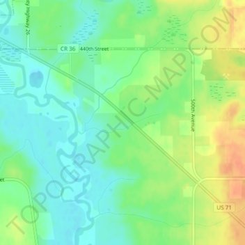
Name: Topografische Karte Judicial Ditch Number Sixtyfour, Höhe, Relief.
Durchschnittliche Höhe: 421 m
Minimale Höhe: 405 m
Maximale Höhe: 444 m
Andere topografische Karten
Klicken Sie auf eine Karte, um ihre Topografie, ihre Höhe und ihr Relief anzuzeigen.
Lake Victoria
USA > Minnesota > Alexandria
Lake Victoria, Rosewood Circle Southeast, Alexandria, Douglas County, Minnesota, 56308, USA
Durchschnittliche Höhe: 427 m
Falcon Heights
USA > Minnesota > Falcon Heights
Falcon Heights, Ramsey County, Minnesota, USA
Durchschnittliche Höhe: 291 m
Oak Park Heights
USA > Minnesota > Oak Park Heights
Oak Park Heights, Washington County, Minnesota, USA
Durchschnittliche Höhe: 257 m
Beebe Lake
Beebe Lake, County Road 82, Dalton, Otter Tail County, Minnesota, 56309, USA
Durchschnittliche Höhe: 396 m
Four Corners
USA > Minnesota > Four Corners
Four Corners, Saint Louis County, Minnesota, USA
Durchschnittliche Höhe: 438 m
Cathedral Hill Park
USA > Minnesota > Saint Paul
Cathedral Hill Park, Saint Paul, Ramsey County, Minnesota, USA
Durchschnittliche Höhe: 252 m
Rainy Lake
USA > Minnesota > Parkers Prairie Park
Rainy Lake, 108th Street, Parkers Prairie Park, Otter Tail County, Minnesota, 56361, USA
Durchschnittliche Höhe: 438 m
Whittier
USA > Minnesota > Minneapolis
Whittier, Minneapolis, Hennepin County, Minnesota, USA
Durchschnittliche Höhe: 268 m
Dunbar River
Dunbar River, Itasca County, Minnesota, 56681, USA
Durchschnittliche Höhe: 404 m
Boga Lake
USA > Minnesota > Forest Center
Boga Lake, Forest Rt 376, Forest Center, Lake County, Minnesota, USA
Durchschnittliche Höhe: 482 m
Kettle River
Kettle River, Carlton County, Minnesota, 55757, USA
Durchschnittliche Höhe: 367 m
Alexandria
USA > Minnesota > Alexandria
Alexandria, Douglas County, Minnesota, 56308, USA
Durchschnittliche Höhe: 426 m
Keller Lake
Keller Lake, North Maplewood Drive, Maplewood, Ramsey County, Minnesota, 55109, USA
Durchschnittliche Höhe: 272 m