
Topografische Karte Bartlett
Interaktive Karte
Klicken Sie auf die Karte, um die Höhe anzuzeigen.
Über diese Karte
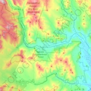
Name: Topografische Karte Bartlett, Höhe, Relief.
Ort: Bartlett, Carroll County, New Hampshire, United States (44.02223 -71.38260 44.13978 -71.08385)
Durchschnittliche Höhe: 493 m
Minimale Höhe: 137 m
Maximale Höhe: 1.285 m
According to the United States Census Bureau, the town has a total area of 75.3 square miles (195 km2), of which 74.9 square miles (194 km2) is land and 0.4 square miles (1.0 km2), or 0.57%, is water. Bartlett is drained by the Saco and Ellis rivers. The highest point in Bartlett is Mount Tremont, elevation 3,371 feet (1,027 m) above sea level. Mount Parker, elevation 3,004 ft (916 m), is in the north, and Bear Mountain, elevation 3,200 ft (980 m), is on the southern boundary. Bartlett lies fully within the Saco River watershed.
Andere topografische Karten
Klicken Sie auf eine Karte, um ihre Topografie, ihre Höhe und ihr Relief anzuzeigen.
Eaton
United States > New Hampshire > Carroll County
Eaton, Carroll County, New Hampshire, 03832, United States
Durchschnittliche Höhe: 262 m
Ossipee
United States > New Hampshire > Carroll County
Ossipee, Carroll County, New Hampshire, United States
Durchschnittliche Höhe: 217 m
Sandwich
United States > New Hampshire > Carroll County
Sandwich, Carroll County, New Hampshire, 03259, United States
Durchschnittliche Höhe: 373 m
Flat Mountain
United States > New Hampshire > Carroll County > Sandwich
Flat Mountain, Sandwich, Carroll County, New Hampshire, United States
Durchschnittliche Höhe: 629 m
Moultonborough
United States > New Hampshire > Carroll County
Moultonborough, Carroll County, New Hampshire, United States
Durchschnittliche Höhe: 243 m
Albany
United States > New Hampshire > Carroll County > Albany
Albany, Carroll County, New Hampshire, United States
Durchschnittliche Höhe: 276 m
Bayle Mountain
United States > New Hampshire > Carroll County > Ossipee
Bayle Mountain, Ossipee, Carroll County, New Hampshire, United States
Durchschnittliche Höhe: 405 m
Whitton Pond
United States > New Hampshire > Carroll County > Albany
Whitton Pond, Albany, Carroll County, New Hampshire, United States
Durchschnittliche Höhe: 273 m
Wolfeboro
United States > New Hampshire > Carroll County
Wolfeboro, Carroll County, New Hampshire, United States
Durchschnittliche Höhe: 213 m
Albany
United States > New Hampshire > Carroll County > Albany
Albany, Carroll County, New Hampshire, 03818, United States
Durchschnittliche Höhe: 409 m
Tamworth
United States > New Hampshire > Carroll County > Tamworth
Tamworth, Carroll County, New Hampshire, United States
Durchschnittliche Höhe: 263 m
Conway
United States > New Hampshire > Carroll County
Conway, Carroll County, New Hampshire, United States
Durchschnittliche Höhe: 256 m
Freedom
United States > New Hampshire > Carroll County
Freedom, Carroll County, New Hampshire, 03836, United States
Durchschnittliche Höhe: 224 m