
Topografische Karte Ternay
Interaktive Karte
Klicken Sie auf die Karte, um die Höhe anzuzeigen.
Über diese Karte
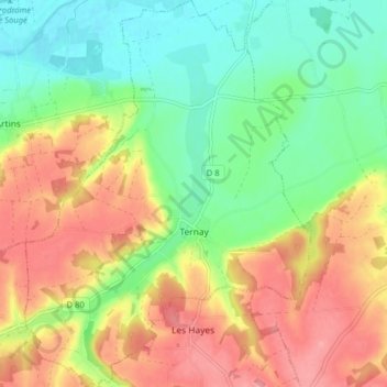
Name: Topografische Karte Ternay, Höhe, Relief.
Durchschnittliche Höhe: 99 m
Minimale Höhe: 57 m
Maximale Höhe: 147 m
L'altitude du territoire communal varie de 59 mètres à 139 mètres.
Andere topografische Karten
Klicken Sie auf eine Karte, um ihre Topografie, ihre Höhe und ihr Relief anzuzeigen.
Thenay
France > Centre-Val de Loire > Loir-et-Cher > Le Controis-en-Sologne
Thenay, Le Controis-en-Sologne, Romorantin-Lanthenay, Loir-et-Cher, Centre-Val de Loire, France métropolitaine, 41400, France
Durchschnittliche Höhe: 104 m
Vendôme
France > Centre-Val de Loire > Loir-et-Cher
Vendôme, Loir-et-Cher, Centre-Val de Loire, France métropolitaine, 41100, France
Durchschnittliche Höhe: 110 m
Blois
France > Centre-Val de Loire > Loir-et-Cher
Blois, Loir-et-Cher, Centre-Val de Loire, France métropolitaine, 41000, France
Durchschnittliche Höhe: 95 m