
Topografische Karte Lake County
Interaktive Karte
Klicken Sie auf die Karte, um die Höhe anzuzeigen.
Über diese Karte
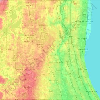
Name: Topografische Karte Lake County, Höhe, Relief.
Ort: Lake County, Illinois, USA (42.15231 -88.19954 42.49563 -87.74949)
Durchschnittliche Höhe: 222 m
Minimale Höhe: 173 m
Maximale Höhe: 293 m
Andere topografische Karten
Klicken Sie auf eine Karte, um ihre Topografie, ihre Höhe und ihr Relief anzuzeigen.
Highland Park
USA > Illinois > Highland Park
Highland Park, Lake County, Illinois, 60035, USA
Durchschnittliche Höhe: 194 m
Mount Prospect
USA > Illinois > Mount Prospect
Mount Prospect, Cook County, Illinois, USA
Durchschnittliche Höhe: 205 m
Montague Island
Montague Island, Rockford, Winnebago County, Illinois, 61104, USA
Durchschnittliche Höhe: 254 m