
Topografische Karte Lombok
Interaktive Karte
Klicken Sie auf die Karte, um die Höhe anzuzeigen.
Über diese Karte
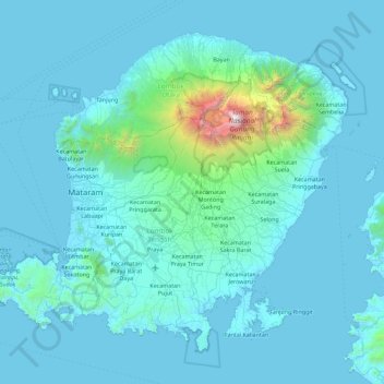
Name: Topografische Karte Lombok, Höhe, Relief.
Durchschnittliche Höhe: 192 m
Minimale Höhe: -1 m
Maximale Höhe: 3.605 m
The island's topography is dominated by the centrally-located stratovolcano Mount Rinjani, the second-highest volcano in Indonesia, which rises to 3,726 metres (12,224 ft), making Lombok the 8th-highest island. The most recent eruption of Rinjani occurred in September 2016 at Gunung Barujari. In a 2010 eruption, ash was reported as rising 2 kilometres (1.2 miles) into the atmosphere from the Barujari cone in Rinjani's caldera lake of Segara Anak. Lava flowed into the caldera lake, raising its temperature, while ash fall damaged crops on the slopes of Rinjani. The volcano and its crater lake, Segara Anak (child of the sea), are protected by the Gunung Rinjani National Park established in 1997. Recent evidence indicates an ancient volcano, Mount Samalas, of which now only a caldera remains, was the source of the 1257 Samalas eruption, one of the largest volcanic eruptions in recorded history, which caused worldwide changes in weather.
Andere topografische Karten
Klicken Sie auf eine Karte, um ihre Topografie, ihre Höhe und ihr Relief anzuzeigen.
West Nusa Tenggara
Indonesia > West Nusa Tenggara
West Nusa Tenggara, Indonesia
Durchschnittliche Höhe: 31 m
Kabupaten Bima
Indonesia > West Nusa Tenggara
Kabupaten Bima, West Nusa Tenggara, 84171, Indonesia
Durchschnittliche Höhe: 90 m
Kecamatan Praya Timur
Indonesia > West Nusa Tenggara > Kecamatan Praya Timur
Kecamatan Praya Timur, Kabupaten Lombok Tengah, West Nusa Tenggara, Indonesia
Durchschnittliche Höhe: 155 m