
Topografische Karte Yquelon
Interaktive Karte
Klicken Sie auf die Karte, um die Höhe anzuzeigen.
Über diese Karte
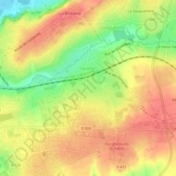
Name: Topografische Karte Yquelon, Höhe, Relief.
Durchschnittliche Höhe: 45 m
Minimale Höhe: 6 m
Maximale Höhe: 68 m
Andere topografische Karten
Klicken Sie auf eine Karte, um ihre Topografie, ihre Höhe und ihr Relief anzuzeigen.
Utah-Beach
France > Normandy > Manche > Sainte-Marie-du-Mont
Utah-Beach, Sainte-Marie-du-Mont, Cherbourg, Manche, Normandy, Metropolitan France, 50480, France
Durchschnittliche Höhe: 1 m
Saint-Pierre-Langers
Saint-Pierre-Langers, Avranches, Manche, Normandy, Metropolitan France, 50530, France
Durchschnittliche Höhe: 68 m
Mortain
France > Normandy > Manche > Mortain-Bocage
Mortain, Mortain-Bocage, Avranches, Manche, Normandy, Metropolitan France, 50140, France
Durchschnittliche Höhe: 216 m
Jullouville
Jullouville, Avranches, Manche, Normandy, Metropolitan France, 50610, France
Durchschnittliche Höhe: 29 m
Gouville-sur-Mer
France > Normandy > Manche > Gouville-sur-Mer
Gouville-sur-Mer, Coutances, Manche, Normandy, Metropolitan France, 50560, France
Durchschnittliche Höhe: 21 m
Marigny-Le-Lozon
Marigny-Le-Lozon, Saint-Lô, Manche, Normandy, Metropolitan France, 50570, France
Durchschnittliche Höhe: 61 m
Agon-Coutainville
Agon-Coutainville, Coutances, Manche, Normandy, Metropolitan France, 50230, France
Durchschnittliche Höhe: 11 m
Tessy-Bocage
Tessy-Bocage, Saint-Lô, Manche, Normandy, Metropolitan France, 50420, France
Durchschnittliche Höhe: 117 m
Saint-Sauveur-Villages
Saint-Sauveur-Villages, Coutances, Manche, Normandy, Metropolitan France, 50490, France
Durchschnittliche Höhe: 67 m
Bourgvallées
Bourgvallées, Saint-Lô, Manche, Normandy, Metropolitan France, 50750, France
Durchschnittliche Höhe: 87 m
Torigny-les-Villes
Torigny-les-Villes, Saint-Lô, Manche, Normandy, Metropolitan France, 50160, France
Durchschnittliche Höhe: 155 m
Condé-sur-Vire
France > Normandy > Manche > Condé-sur-Vire
Condé-sur-Vire, Saint-Lô, Manche, Normandy, Metropolitan France, 50890, France
Durchschnittliche Höhe: 84 m
Villedieu-les-Poêles-Rouffigny
Villedieu-les-Poêles-Rouffigny, Saint-Lô, Manche, Normandy, Metropolitan France, 50800, France
Durchschnittliche Höhe: 166 m
Donville-les-Bains
Donville-les-Bains, Avranches, Manche, Normandy, Metropolitan France, 50350, France
Durchschnittliche Höhe: 17 m
Portbail
France > Normandy > Manche > Port-Bail-sur-Mer
Portbail, Port-Bail-sur-Mer, Cherbourg, Manche, Normandy, Metropolitan France, 50580, France
Durchschnittliche Höhe: 26 m
La Bihellerie
France > Normandy > Manche > Pierreville
La Bihellerie, Pierreville, Cherbourg, Manche, Normandy, Metropolitan France, 50340, France
Durchschnittliche Höhe: 68 m
La Coquaise
France > Normandy > Manche > Flamanville
La Coquaise, Flamanville, Cherbourg, Manche, Normandy, Metropolitan France, 50340, France
Durchschnittliche Höhe: 33 m
La Rue de Bas
France > Normandy > Manche > Blainville-sur-Mer
La Rue de Bas, Blainville-sur-Mer, Coutances, Manche, Normandy, Metropolitan France, 50560, France
Durchschnittliche Höhe: 20 m
La Petite Mazure
France > Normandy > Manche > Saint-Hilaire-du-Harcouët
La Petite Mazure, Saint-Hilaire-du-Harcouët, Avranches, Manche, Normandy, Metropolitan France, 50600, France
Durchschnittliche Höhe: 90 m
Les Acacias
France > Normandy > Manche > Port-Bail-sur-Mer > Portbail
Les Acacias, Portbail, Port-Bail-sur-Mer, Cherbourg, Manche, Normandy, Metropolitan France, 50580, France
Durchschnittliche Höhe: 6 m
Le Petit Hameau
France > Normandy > Manche > Barneville-Carteret
Le Petit Hameau, Barneville-Carteret, Cherbourg, Manche, Normandy, Metropolitan France, 50270, France
Durchschnittliche Höhe: 21 m
Hauteville-sur-Mer
Hauteville-sur-Mer, Coutances, Manche, Normandy, Metropolitan France, 50590, France
Durchschnittliche Höhe: 21 m
Le Valnotte
France > Normandy > Manche > Carteret
Le Valnotte, Carteret, Barneville-Carteret, Cherbourg, Manche, Normandy, Metropolitan France, 50270, France
Durchschnittliche Höhe: 35 m
Montmartin-sur-Mer
Montmartin-sur-Mer, Coutances, Manche, Normandy, Metropolitan France, 50590, France
Durchschnittliche Höhe: 31 m
Saint-Martin-le-Vieux
France > Normandy > Manche > Bréhal
Saint-Martin-le-Vieux, Bréhal, Avranches, Manche, Normandy, Metropolitan France, 50290, France
Durchschnittliche Höhe: 22 m
Hameau Val Fontaine
France > Normandy > Manche > Bricquebec-en-Cotentin > Les Perques
Hameau Val Fontaine, Les Perques, Bricquebec-en-Cotentin, Cherbourg, Manche, Normandy, Metropolitan France, 50260, France
Durchschnittliche Höhe: 66 m
Les Moitiers-d'Allonne
Les Moitiers-d'Allonne, Cherbourg, Manche, Normandy, Metropolitan France, 50270, France
Durchschnittliche Höhe: 51 m
Le Clos Versailles
France > Normandy > Manche > La Haye-du-Puits
Le Clos Versailles, La Haye-du-Puits, La Haye, Coutances, Manche, Normandy, Metropolitan France, 50250, France
Durchschnittliche Höhe: 51 m
La Planquette
France > Normandy > Manche > Gavray-sur-Sienne > Gavray
La Planquette, Gavray, Gavray-sur-Sienne, Coutances, Manche, Normandy, Metropolitan France, 50450, France
Durchschnittliche Höhe: 76 m
L'Hôtel Boschet
France > Normandy > Manche > Cérences
L'Hôtel Boschet, Cérences, Avranches, Manche, Normandy, Metropolitan France, 50510, France
Durchschnittliche Höhe: 49 m
Hameau Viel
France > Normandy > Manche > Flamanville
Hameau Viel, Flamanville, Cherbourg, Manche, Normandy, Metropolitan France, 50340, France
Durchschnittliche Höhe: 35 m
Cherbourg-en-Cotentin
Cherbourg-en-Cotentin, Cherbourg, Manche, Normandy, Metropolitan France, France
Durchschnittliche Höhe: 67 m
Sainte-Mère-Église
France > Normandy > Manche > Sainte-Mère-Église
Sainte-Mère-Église, Cherbourg, Manche, Normandy, Metropolitan France, 50480, France
Durchschnittliche Höhe: 17 m
Hameau des Champs
France > Normandy > Manche > Cherbourg-en-Cotentin
Hameau des Champs, Tourlaville, Cherbourg-en-Cotentin, Cherbourg, Manche, Normandy, Metropolitan France, 50110, France
Durchschnittliche Höhe: 76 m
L'Hôtel au Roy
France > Normandy > Manche > Cérences
L'Hôtel au Roy, Cérences, Avranches, Manche, Normandy, Metropolitan France, 50510, France
Durchschnittliche Höhe: 51 m
Sartilly-Baie-Bocage
Sartilly-Baie-Bocage, Avranches, Manche, Normandy, Metropolitan France, 50530, France
Durchschnittliche Höhe: 81 m
Saint-Jean-de-Daye
Saint-Jean-de-Daye, Saint-Lô, Manche, Normandy, Metropolitan France, 50620, France
Durchschnittliche Höhe: 23 m
Le Mont-Saint-Michel
Le Mont-Saint-Michel, Avranches, Manche, Normandy, Metropolitan France, 50170, France
Durchschnittliche Höhe: 5 m