
Topografische Karte Garfield Heights
Interaktive Karte
Klicken Sie auf die Karte, um die Höhe anzuzeigen.
Garfield Heights
According to the United States Census Bureau, the city has a total area of 7.29 square miles (18.88 km2), of which 7.23 square miles (18.73 km2) is land and 0.06 square miles (0.16 km2) is water. The elevation of Garfield Heights is 831 feet (253 m) above sea level where it borders Cleveland, and its highest elevation is 972 feet (296 m) above sea level at the Garfield Heights Justice Center.
Über diese Karte
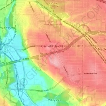
Name: Topografische Karte Garfield Heights, Höhe, Relief.
Durchschnittliche Höhe: 251 m
Minimale Höhe: 178 m
Maximale Höhe: 308 m
Andere topografische Karten
Klicken Sie auf eine Karte, um ihre Topografie, ihre Höhe und ihr Relief anzuzeigen.
Cleveland
United States > Ohio > Cuyahoga County > Cleveland
The land rises quickly from the lake shore elevation of 569 feet. Public Square, less than one mile (1.6 km) inland, sits at an elevation of 650 feet (198 m), and Hopkins Airport, 5 miles (8 km) inland from the lake, is at an elevation of 791 feet (241 m).
Durchschnittliche Höhe: 219 m
West Dover
United States > Ohio > Cuyahoga County > Westlake > West Dover
Durchschnittliche Höhe: 194 m