
Topografische Karte Rosedale
Interaktive Karte
Klicken Sie auf die Karte, um die Höhe anzuzeigen.
Über diese Karte
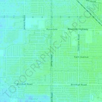
Name: Topografische Karte Rosedale, Höhe, Relief.
Ort: Rosedale, Kern County, Californie, États-Unis d'Amérique (35.37623 -119.14581 35.37924 -119.14554)
Durchschnittliche Höhe: 113 m
Minimale Höhe: 109 m
Maximale Höhe: 116 m
Andere topografische Karten
Klicken Sie auf eine Karte, um ihre Topografie, ihre Höhe und ihr Relief anzuzeigen.
China Lake
États-Unis d'Amérique > Californie > Kern County > Ridgecrest
China Lake, Ridgecrest, Kern County, Californie, 93555, États-Unis d'Amérique
Durchschnittliche Höhe: 683 m
Taft
États-Unis d'Amérique > Californie > Kern County
Taft, Kern County, Californie, 93268, États-Unis d'Amérique
Durchschnittliche Höhe: 370 m
Johnson Canyon
États-Unis d'Amérique > Californie > Kern County
Johnson Canyon, Kern County, Californie, 93243, États-Unis d'Amérique
Durchschnittliche Höhe: 1.196 m
Taft Heights
États-Unis d'Amérique > Californie > Kern County > Taft > Taft Heights
Taft Heights, Taft, Kern County, CAL Fire Contract Counties, Californie, États-Unis d'Amérique
Durchschnittliche Höhe: 368 m
Wherry Housing
États-Unis d'Amérique > Californie > Kern County
Wherry Housing, Kern County, Californie, 93523, États-Unis d'Amérique
Durchschnittliche Höhe: 731 m
Rosedale
États-Unis d'Amérique > Californie > Kern County
Rosedale, Kern County, CAL Fire Southern Region, Californie, États-Unis d'Amérique
Durchschnittliche Höhe: 107 m
Keene
États-Unis d'Amérique > Californie > Kern County
Keene, Kern County, Californie, 93531, États-Unis d'Amérique
Durchschnittliche Höhe: 892 m
Woody
États-Unis d'Amérique > Californie > Kern County
Woody, Kern County, Californie, 93287, États-Unis d'Amérique
Durchschnittliche Höhe: 597 m