
Topografische Karte Imogene Pass
Interaktive Karte
Klicken Sie auf die Karte, um die Höhe anzuzeigen.
Über diese Karte
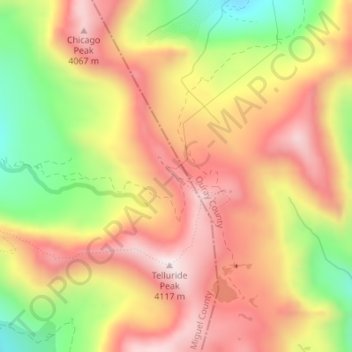
Name: Topografische Karte Imogene Pass, Höhe, Relief.
Durchschnittliche Höhe: 3.837 m
Minimale Höhe: 3.495 m
Maximale Höhe: 4.096 m
Andere topografische Karten
Klicken Sie auf eine Karte, um ihre Topografie, ihre Höhe und ihr Relief anzuzeigen.
Blue Lake
United States > Colorado > San Miguel County
Blue Lake, San Miguel County, Colorado, United States
Durchschnittliche Höhe: 3.823 m
Telluride
United States > Colorado > San Miguel County
Telluride, San Miguel County, Colorado, 81435, United States
Durchschnittliche Höhe: 3.125 m
Placerville
United States > Colorado > San Miguel County
Placerville, San Miguel County, Colorado, 81430, United States
Durchschnittliche Höhe: 2.460 m
Cushman Dam
United States > Colorado > San Miguel County
Cushman Dam, San Miguel County, Colorado, 81426, United States
Durchschnittliche Höhe: 2.867 m
Bridal Veil Creek
United States > Colorado > San Miguel County
Bridal Veil Creek, San Miguel County, Colorado, United States
Durchschnittliche Höhe: 3.737 m
Mountain Village
United States > Colorado > San Miguel County
Mountain Village, San Miguel County, Colorado, United States
Durchschnittliche Höhe: 2.917 m
Noel
United States > Colorado > San Miguel County
Noel, San Miguel County, Colorado, United States
Durchschnittliche Höhe: 2.774 m
Pandora
United States > Colorado > San Miguel County > Pandora
Pandora, San Miguel County, Colorado, 81435, United States
Durchschnittliche Höhe: 3.174 m
Telluride
United States > Colorado > San Miguel County > Telluride
Telluride, San Miguel County, Colorado, 8145, United States
Durchschnittliche Höhe: 3.246 m
Telluride Peak
United States > Colorado > San Miguel County
Telluride Peak, San Miguel County, Colorado, 81231, United States
Durchschnittliche Höhe: 3.843 m