
Topografische Karte Isières
Interaktive Karte
Klicken Sie auf die Karte, um die Höhe anzuzeigen.
Über diese Karte
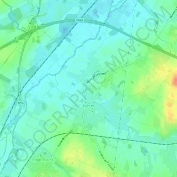
Name: Topografische Karte Isières, Höhe, Relief.
Ort: Isières, Ath, Hainaut, Wallonie, Belgique (50.65018 3.79307 50.68381 3.84322)
Durchschnittliche Höhe: 31 m
Minimale Höhe: 19 m
Maximale Höhe: 62 m
Andere topografische Karten
Klicken Sie auf eine Karte, um ihre Topografie, ihre Höhe und ihr Relief anzuzeigen.
Ghislenghien
Belgique > Hainaut > Ath > Ath
Ghislenghien, Ath, Hainaut, Wallonie, Belgique
Durchschnittliche Höhe: 48 m
Villers-Notre-Dame
Belgique > Hainaut > Ath > Ath
Villers-Notre-Dame, Ath, Hainaut, Wallonie, Belgique
Durchschnittliche Höhe: 49 m
Canal Blaton - Ath
Belgique > Hainaut > Ath > Ath
Canal Blaton - Ath, Ath, Hainaut, Wallonie, 7800, Belgique
Durchschnittliche Höhe: 40 m
Meslin-l'Évêque
Belgique > Hainaut > Ath > Ath > Meslin-l'Évêque
Meslin-l'Évêque, Ath, Hainaut, Wallonie, 7822, Belgique
Durchschnittliche Höhe: 47 m
Lanquesaint
Belgique > Hainaut > Ath > Ath
Lanquesaint, Ath, Hainaut, Wallonie, 7800, Belgique
Durchschnittliche Höhe: 38 m