
Topografische Karte Johns Creek
Interaktive Karte
Klicken Sie auf die Karte, um die Höhe anzuzeigen.
Über diese Karte
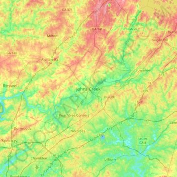
Name: Topografische Karte Johns Creek, Höhe, Relief.
Ort: Johns Creek, Fulton County, Georgia, 30097, United States (33.85816 -84.35020 34.17816 -84.03020)
Durchschnittliche Höhe: 314 m
Minimale Höhe: 253 m
Maximale Höhe: 402 m
Johns Creek is located in northeastern Fulton County and is centered at 34°1′44″N 84°11′55″W / 34.02889°N 84.19861°W / 34.02889; -84.19861 (34.0289259, -84.1985790). The elevation ranges from 880 feet (270 m) above sea level along the Chattahoochee River to 1,180 feet (360 m) in the Ocee area along the Alpharetta border. Johns Creek is bounded to the south by the Chattahoochee River and Gwinnett County, and on the northeast by McGinnis Ferry Road and Forsyth County. It is bounded by Roswell to the west, Alpharetta to the northwest, Suwanee to the east, and Duluth, Berkeley Lake, and Peachtree Corners to the south. Downtown Atlanta is 27 miles (43 km) to the southwest.
Andere topografische Karten
Klicken Sie auf eine Karte, um ihre Topografie, ihre Höhe und ihr Relief anzuzeigen.
Shake Rag
United States > Georgia > Fulton County > Johns Creek
Shake Rag, Johns Creek, Fulton County, Georgia, 30095, United States
Durchschnittliche Höhe: 300 m
Johns Creek
United States > Georgia > Fulton County > Johns Creek > Johns Creek
Johns Creek, Fulton County, Georgia, 30097, United States
Durchschnittliche Höhe: 305 m