
Topografische Karte Folding Mountain
Interaktive Karte
Klicken Sie auf die Karte, um die Höhe anzuzeigen.
Über diese Karte
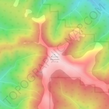
Name: Topografische Karte Folding Mountain, Höhe, Relief.
Ort: Folding Mountain, Yellowhead County, Alberta, Canada (53.21264 -117.70480 53.21274 -117.70470)
Durchschnittliche Höhe: 1.806 m
Minimale Höhe: 1.440 m
Maximale Höhe: 2.114 m
Andere topografische Karten
Klicken Sie auf eine Karte, um ihre Topografie, ihre Höhe und ihr Relief anzuzeigen.
Brazeau River Provincial Recreation Area
Canada > Alberta > Yellowhead County
Brazeau River Provincial Recreation Area, Forestry Trunk Road, Yellowhead County, Alberta, Canada
Durchschnittliche Höhe: 1.325 m
Brule
Canada > Alberta > Yellowhead County
Brule, Yellowhead County, Alberta, Canada
Durchschnittliche Höhe: 1.135 m
Rock Lake Provincial Park
Canada > Alberta > Yellowhead County
Rock Lake Provincial Park, Yellowhead County, Alberta, Canada
Durchschnittliche Höhe: 1.612 m
Yates Natural Area
Canada > Alberta > Yellowhead County
Yates Natural Area, Township Road 534, Yellowhead County, Alberta, Canada
Durchschnittliche Höhe: 880 m
Peers
Canada > Alberta > Yellowhead County
Peers, Yellowhead County, Alberta, Canada
Durchschnittliche Höhe: 850 m
Fairfax Lake
Canada > Alberta > Yellowhead County
Fairfax Lake, Yellowhead County, Alberta, Canada
Durchschnittliche Höhe: 1.347 m
Robb
Canada > Alberta > Yellowhead County
Robb, Yellowhead County, Alberta, Canada
Durchschnittliche Höhe: 1.142 m
Luscar
Canada > Alberta > Yellowhead County
Luscar, Yellowhead County, Alberta, Canada
Durchschnittliche Höhe: 1.718 m