
Topografische Karte Atherton
Interaktive Karte
Klicken Sie auf die Karte, um die Höhe anzuzeigen.
Über diese Karte
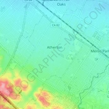
Name: Topografische Karte Atherton, Höhe, Relief.
Durchschnittliche Höhe: 30 m
Minimale Höhe: 4 m
Maximale Höhe: 124 m
Andere topografische Karten
Klicken Sie auf eine Karte, um ihre Topografie, ihre Höhe und ihr Relief anzuzeigen.
San Carlos
États-Unis d'Amérique > Californie > San Mateo County
San Carlos, San Mateo County, Californie, 94070, États-Unis d'Amérique
Durchschnittliche Höhe: 47 m
Daly City
États-Unis d'Amérique > Californie > San Mateo County
Daly City, San Mateo County, Californie, États-Unis d'Amérique
Durchschnittliche Höhe: 75 m
Redwood City
États-Unis d'Amérique > Californie > San Mateo County > Redwood City
Redwood City, San Mateo County, Californie, 94063, États-Unis d'Amérique
Durchschnittliche Höhe: 101 m
San Francisco Bay
États-Unis d'Amérique > Californie > San Mateo County
San Francisco Bay, San Mateo County, CAL Fire Northern Region, Californie, États-Unis d'Amérique
Durchschnittliche Höhe: 75 m
Colma
États-Unis d'Amérique > Californie > San Mateo County > Colma
Colma, San Mateo County, Californie, États-Unis d'Amérique
Durchschnittliche Höhe: 82 m
Redwood City
États-Unis d'Amérique > Californie > San Mateo County
Redwood City, San Mateo County, CAL Fire Northern Region, Californie, États-Unis d'Amérique
Durchschnittliche Höhe: 32 m