
Topografische Karte Renukut
Interaktive Karte
Klicken Sie auf die Karte, um die Höhe anzuzeigen.
Über diese Karte
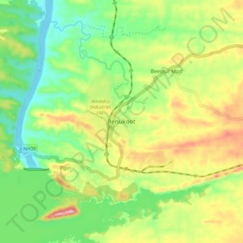
Name: Topografische Karte Renukut, Höhe, Relief.
Durchschnittliche Höhe: 285 m
Minimale Höhe: 194 m
Maximale Höhe: 423 m
Renukoot is located at 24°12′N 83°02′E / 24.2°N 83.03°E / 24.2; 83.03. It has an average elevation of 283 metres (931 feet). Renukoot lies in the southeast-most part of Uttar Pradesh and sits next to Shakti Nagar, Anpara, ((Dalla)) and Obra. Renukoot is in Sonebhadra district which is the only district in India which borders four states, namely Madhya Pradesh, Chhattisgarh, Jharkhand, and Bihar.