
Topografische Karte Addison (Webster Springs)
Interaktive Karte
Klicken Sie auf die Karte, um die Höhe anzuzeigen.
Über diese Karte
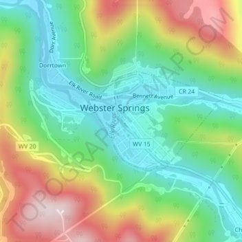
Name: Topografische Karte Addison (Webster Springs), Höhe, Relief.
Durchschnittliche Höhe: 602 m
Minimale Höhe: 431 m
Maximale Höhe: 878 m
Webster Springs is located at 38°28′34″N 80°24′36″W / 38.47611°N 80.41000°W / 38.47611; -80.41000 (38.476192, -80.410025), along the Elk River. According to the United States Census Bureau, the town has a total area of 0.47 square miles (1.22 km2), of which 0.45 square miles (1.17 km2) is land and 0.02 square miles (0.05 km2) is water. It lies at an elevation of 1,460 ft. (445m) and is close to Buffalo Bull Knob, elevation 2,799 ft.
Andere topografische Karten
Klicken Sie auf eine Karte, um ihre Topografie, ihre Höhe und ihr Relief anzuzeigen.
Diana
United States > West Virginia > Webster County
Diana, Webster County, West Virginia, 26217, United States
Durchschnittliche Höhe: 553 m
Hacker Valley
United States > West Virginia > Webster County
Hacker Valley, Webster County, West Virginia, 26222, United States
Durchschnittliche Höhe: 582 m
Cowen
United States > West Virginia > Webster County
Cowen, Webster County, West Virginia, 26206, United States
Durchschnittliche Höhe: 709 m
Holly River State Park
United States > West Virginia > Webster County
Holly River State Park, Webster County, West Virginia, United States
Durchschnittliche Höhe: 674 m
Big Ditch Lake
United States > West Virginia > Webster County
Big Ditch Lake, Webster County, West Virginia, United States
Durchschnittliche Höhe: 708 m