
Topografische Karte Ojén
Interaktive Karte
Klicken Sie auf die Karte, um die Höhe anzuzeigen.
Über diese Karte
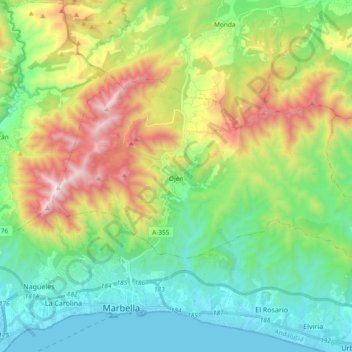
Name: Topografische Karte Ojén, Höhe, Relief.
Ort: Ojén, Sierra de las Nieves, Malaga, Andalusia, 29610, Spain (36.52108 -4.92218 36.60949 -4.73540)
Durchschnittliche Höhe: 404 m
Minimale Höhe: -1 m
Maximale Höhe: 1.254 m
The town is situated beside the Almadán stream above the valley of the River Real at an altitude of approximately 200 metres, hemmed in by the Sierra Blanca and the Sierra Alpujata. These may provide a clue to the Moors' determination to stay in spite of their apparent antipathy, for both ranges of mountains have long been known as rich sources of talc, nickel, iron and lead. This mineral wealth put the area in the forefront of the Spanish industrial revolution of the 19th century.
Andere topografische Karten
Klicken Sie auf eine Karte, um ihre Topografie, ihre Höhe und ihr Relief anzuzeigen.
Guaro
Spain > Andalusia > Sierra de las Nieves
Guaro, Sierra de las Nieves, Malaga, Andalusia, 29108, Spain
Durchschnittliche Höhe: 259 m
Sierra Real
Spain > Andalusia > Sierra de las Nieves > Istán
Sierra Real, Istán, Sierra de las Nieves, Malaga, Andalusia, Spain
Durchschnittliche Höhe: 993 m
Tolox
Spain > Andalusia > Sierra de las Nieves
Tolox, Sierra de las Nieves, Malaga, Andalusia, 29109, Spain
Durchschnittliche Höhe: 608 m