
Topografische Karte La Barbinière
Interaktive Karte
Klicken Sie auf die Karte, um die Höhe anzuzeigen.
Über diese Karte
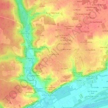
Name: Topografische Karte La Barbinière, Höhe, Relief.
Durchschnittliche Höhe: 79 m
Minimale Höhe: 38 m
Maximale Höhe: 105 m
Andere topografische Karten
Klicken Sie auf eine Karte, um ihre Topografie, ihre Höhe und ihr Relief anzuzeigen.
Sous le Château
France > Centre-Val de Loire > Indre-et-Loire > Luynes
Sous le Château, Luynes, Arrondissement de Tours, Indre-et-Loire, Centre-Val de Loire, France métropolitaine, 37230, France
Durchschnittliche Höhe: 67 m
Le Bas Saint-Venant
France > Centre-Val de Loire > Indre-et-Loire > Luynes
Le Bas Saint-Venant, Luynes, Tours, Indre-et-Loire, Centre-Val de Loire, France métropolitaine, 37230, France
Durchschnittliche Höhe: 65 m
Les Granges
France > Centre-Val de Loire > Indre-et-Loire > Luynes
Les Granges, Luynes, Tours, Indre-et-Loire, Centre-Val de Loire, France métropolitaine, 37230, France
Durchschnittliche Höhe: 60 m