
Spenden
Rüsten Sie sich für Ihr nächstes Abenteuer:
Als Amazon-Partner erhält diese Website eine Provision für qualifizierte Käufe, ohne zusätzliche Kosten für Sie.
Topografische Karte Dera Bugti District
Klicken Sie auf die Karte, um die Höhe anzuzeigen.
Spenden
Rüsten Sie sich für Ihr nächstes Abenteuer:
Als Amazon-Partner erhält diese Website eine Provision für qualifizierte Käufe, ohne zusätzliche Kosten für Sie.
Über diese Karte
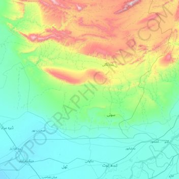
Name: Topografische Karte Dera Bugti District, Höhe, Relief.
Ort: Dera Bugti District, Sibi Division, Pakistan (28.13333 68.30000 29.53333 69.70000)
Durchschnittliche Höhe: 358 m
Minimale Höhe: 53 m
Maximale Höhe: 1.642 m
Spenden
Rüsten Sie sich für Ihr nächstes Abenteuer:
Als Amazon-Partner erhält diese Website eine Provision für qualifizierte Käufe, ohne zusätzliche Kosten für Sie.
Andere topografische Karten
Klicken Sie auf eine Karte, um ihre Topografie, ihre Höhe und ihr Relief anzuzeigen.
Punjab
Punjab's landscape consists mostly consists of fertile alluvial plains of the Indus River and its four major tributaries in Pakistan, the Jhelum, Chenab, Ravi, and Sutlej rivers which traverse Punjab north to south – the fifth of the "five waters" of Punjab, the Beas River, lies exclusively in the Indian…
Durchschnittliche Höhe: 623 m
Karachi Division
Karachi lies very close to a major fault line, where the Indian tectonic plate meets the Arabian tectonic plate. However, Karachi lies near the western edge of the Indian Plate, on the Indo Gangetic Plain. Within the city of Karachi are two small ranges: the Khasa Hills and Mulri Hills, which lie in the…
Durchschnittliche Höhe: 89 m
Spenden
Rüsten Sie sich für Ihr nächstes Abenteuer:
Als Amazon-Partner erhält diese Website eine Provision für qualifizierte Käufe, ohne zusätzliche Kosten für Sie.
Buner District
Buner's elevation starts at 1200 ft in the South in Totalai and reaches a maximum height of 9,550 ft at the Dosara Peak in the North. The majority of the hills that encircle the Buner District are covered in pine trees. Barandu, Chamla, and Budal are the three principal rivers; the former flows through the…
Durchschnittliche Höhe: 953 m
Sindh
There is no evidence of large palaces or large tombs for the elite. The grand and presumably holy site might have been the great bath, which is built upon an artificially created elevation. This civilization collapsed around 1700 BC for reasons that are uncertain; the cause is hotly debated and may have been a…
Durchschnittliche Höhe: 173 m
Spenden
Rüsten Sie sich für Ihr nächstes Abenteuer:
Als Amazon-Partner erhält diese Website eine Provision für qualifizierte Käufe, ohne zusätzliche Kosten für Sie.
Gilgit-Baltistan
Three of the world's longest glaciers outside the polar regions are found in Gilgit-Baltistan: the Biafo Glacier, the Baltoro Glacier, and the Batura Glacier. There are, in addition, several high-altitude lakes in Gilgit-Baltistan.
Durchschnittliche Höhe: 3.949 m
Lakki Marwat District
The district is a combination of hills and sandy plains. The hilly areas are along the boundaries of the district especially in the east, southeast, southwest and northwest. In the southeast, the Marwat range separates Lakki Marwat from Dera Ismail Khan District while in the east the Karak Niazi range…
Durchschnittliche Höhe: 353 m
Spenden
Rüsten Sie sich für Ihr nächstes Abenteuer:
Als Amazon-Partner erhält diese Website eine Provision für qualifizierte Käufe, ohne zusätzliche Kosten für Sie.
Bajaur District
Bajaur is about 45 miles (72 km) long and 20 miles (32 km) wide. It lies at a high elevation to the east of the Kunar Valley of Afghanistan from which it is separated by a continuous line of rugged frontier hills. The old road from Afghanistan's Kabul to Pakistan went through Bajaur before a new pass, Khyber…
Durchschnittliche Höhe: 1.172 m
Spenden
Rüsten Sie sich für Ihr nächstes Abenteuer:
Als Amazon-Partner erhält diese Website eine Provision für qualifizierte Käufe, ohne zusätzliche Kosten für Sie.
Ziarat District
Ziarat (Urdu: ضلع زیارت) is a district in the north of Balochistan province of Pakistan. Ziarat town (situated at an altitude of about 2,400 meters) is the headquarters of the district, the sub-division, and also of the tehsil. The highest peak of Khalifat Hills, at an altitude of 11,400 feet (3,500…
Durchschnittliche Höhe: 1.837 m
Spenden
Rüsten Sie sich für Ihr nächstes Abenteuer:
Als Amazon-Partner erhält diese Website eine Provision für qualifizierte Käufe, ohne zusätzliche Kosten für Sie.
Usta Muhammad Tehsil
Pakistan > Balochistan > Jafarabad District
Usta Mohammad is in the Kachhi plain basin, with an average altitude of about 55 meters. Annual rainfall is about 90mm, of which 60mm falls in winter (November–May). Winters are cold, and summers are dry and hot.
Durchschnittliche Höhe: 53 m
Spenden
Rüsten Sie sich für Ihr nächstes Abenteuer:
Als Amazon-Partner erhält diese Website eine Provision für qualifizierte Käufe, ohne zusätzliche Kosten für Sie.
Spenden
Rüsten Sie sich für Ihr nächstes Abenteuer:
Als Amazon-Partner erhält diese Website eine Provision für qualifizierte Käufe, ohne zusätzliche Kosten für Sie.
Sibi District
Sibi (Urdu and Balochi: سبی ) is a district in the Balochistan province of Pakistan. The climate and topography of Sibi District are quite varied compared to the other districts of Balochistan. It is also known as the "hotspot" of Pakistan, where the temperatures in the summer exceeded 52.6 °C (126.7 °F).…
Durchschnittliche Höhe: 570 m
Nara Canal
Left Bank Outfall Drain to the west of Nara Canal, built much later (starting in the 1960s and 80s) than Nara Canal, the LBOD was designed to solve the waterlogging and salinity problems caused by intensive irrigation from canals like the Nara. It collects salty groundwater and industrial/agricultural waste…
Durchschnittliche Höhe: 37 m
Spenden
Rüsten Sie sich für Ihr nächstes Abenteuer:
Als Amazon-Partner erhält diese Website eine Provision für qualifizierte Käufe, ohne zusätzliche Kosten für Sie.
Barkhan District
The landscape of Barkhan consists of plains, valleys and mountains varying in ground elevation ranging from 841 to 2,031 meters above Mean Sea Level (MSL). The district consists of one main valley, called Barkhan, and several smaller valleys, which are separated from the main valley by low ranges of hills…
Durchschnittliche Höhe: 1.097 m
Spenden
Rüsten Sie sich für Ihr nächstes Abenteuer:
Als Amazon-Partner erhält diese Website eine Provision für qualifizierte Käufe, ohne zusätzliche Kosten für Sie.
Qilla Abdullah District
Kila Abdullah district lies between 30 and 04' to 31–17' North Longitude in the foothills of the Shela Bagh Mountain range. It is bordered by Pishin District in the east, Quetta District in the South and by Afghanistan in the west. The geographical area of the district is 5,264 km2. It is composed of two…
Durchschnittliche Höhe: 1.700 m
Panjgur District
Panjgur District covers an area of 16,891 square kilometres (6,522 sq mi) in western Balochistan, sharing an international border with Sistan and Baluchestan province of Iran to the west. This boundary, known as the Goldsmid Line, was formalised as the Perso-Baloch frontier in the nineteenth century and…
Durchschnittliche Höhe: 857 m
Sherani District
Many wild plants in the area are used by local communities for traditional medicine, food, animal fodder, fencing, and household needs. At higher elevations, forested areas also include Pinus gerardiana (chilghoza pine), which is valued for its edible nuts and local importance.
Durchschnittliche Höhe: 1.312 m
Spenden
Rüsten Sie sich für Ihr nächstes Abenteuer:
Als Amazon-Partner erhält diese Website eine Provision für qualifizierte Käufe, ohne zusätzliche Kosten für Sie.
Spenden
Rüsten Sie sich für Ihr nächstes Abenteuer:
Als Amazon-Partner erhält diese Website eine Provision für qualifizierte Käufe, ohne zusätzliche Kosten für Sie.
Faisalabad City Tehsil
The soil consists of young stratified silt loam or very fine sand loam which makes the subsoil weak in structure with common kankers at only five feet. The course of the rivers within Faisalabad is winding and often subject to frequent alternations. In the rainy season, the currents are very strong. This leads…
Durchschnittliche Höhe: 185 m
Spenden
Rüsten Sie sich für Ihr nächstes Abenteuer:
Als Amazon-Partner erhält diese Website eine Provision für qualifizierte Käufe, ohne zusätzliche Kosten für Sie.
Spenden
Rüsten Sie sich für Ihr nächstes Abenteuer:
Als Amazon-Partner erhält diese Website eine Provision für qualifizierte Käufe, ohne zusätzliche Kosten für Sie.
Spenden
Rüsten Sie sich für Ihr nächstes Abenteuer:
Als Amazon-Partner erhält diese Website eine Provision für qualifizierte Käufe, ohne zusätzliche Kosten für Sie.
Indus River
Pakistan > Gilgit-Baltistan > Kharmang District > Manthokha
In the uppermost, highest part of the Indus River basin there are relatively few genera and species: Diptychus, Ptychobarbus, Schizopyge, Schizopygopsis and Schizothorax snowtrout, Triplophysa loaches, and the catfish Glyptosternon reticulatum. Going downstream these are soon joined by the golden mahseer Tor…
Durchschnittliche Höhe: 2.956 m
Spenden
Rüsten Sie sich für Ihr nächstes Abenteuer:
Als Amazon-Partner erhält diese Website eine Provision für qualifizierte Käufe, ohne zusätzliche Kosten für Sie.
Spenden
Rüsten Sie sich für Ihr nächstes Abenteuer:
Als Amazon-Partner erhält diese Website eine Provision für qualifizierte Käufe, ohne zusätzliche Kosten für Sie.
Spenden
Rüsten Sie sich für Ihr nächstes Abenteuer:
Als Amazon-Partner erhält diese Website eine Provision für qualifizierte Käufe, ohne zusätzliche Kosten für Sie.
Askari 11
Pakistan > Punjab > Rawalpindi District > Rawalpindi Cantonment
Durchschnittliche Höhe: 518 m
Spenden
Rüsten Sie sich für Ihr nächstes Abenteuer:
Als Amazon-Partner erhält diese Website eine Provision für qualifizierte Käufe, ohne zusätzliche Kosten für Sie.
Karachi Division
Karachi lies very close to a major fault line, where the Indian tectonic plate meets the Arabian tectonic plate. However, Karachi lies near the western edge of the Indian Plate, on the Indo Gangetic Plain. Within the city of Karachi are two small ranges: the Khasa Hills and Mulri Hills, which lie in the…
Durchschnittliche Höhe: 89 m
Mastung District
Mastung District is located in the northwest of Balochistan (Pakistan), covering an area of 3,308 km². It lies south of Quetta District, with elevations between 5,600 feet (1,700 m) to 10,000 feet (3,000 m) above sea level.
Durchschnittliche Höhe: 1.617 m
Drosh Tehsil
Pakistan > Khyber Pakhtunkhwa > Chitrāl District
Khowar is by the majority of the people in Drosh with a few speakers of Pashto. Drosh is low elevation and is a large village in Chitral District on the traditional trade route to Drosh-Jalalabad Road.
Durchschnittliche Höhe: 3.012 m
Spenden
Rüsten Sie sich für Ihr nächstes Abenteuer:
Als Amazon-Partner erhält diese Website eine Provision für qualifizierte Käufe, ohne zusätzliche Kosten für Sie.
Gwadar District
Gwadar District is situated on a thin strip of land along Pakistan's southwestern Arabian Sea coast in Balochistan province. The district is separated into five Tehsils: the city of Jiwani in the southwest along the eastern edge of Gwatar Bay, bordered by Gwadar Tehsil to its north and east; Pasni Tehsil is…
Durchschnittliche Höhe: 279 m
Spenden
Rüsten Sie sich für Ihr nächstes Abenteuer:
Als Amazon-Partner erhält diese Website eine Provision für qualifizierte Käufe, ohne zusätzliche Kosten für Sie.
Spenden
Rüsten Sie sich für Ihr nächstes Abenteuer:
Als Amazon-Partner erhält diese Website eine Provision für qualifizierte Käufe, ohne zusätzliche Kosten für Sie.
Spenden
Rüsten Sie sich für Ihr nächstes Abenteuer:
Als Amazon-Partner erhält diese Website eine Provision für qualifizierte Käufe, ohne zusätzliche Kosten für Sie.
Dir Gol
Pakistan > Khyber Pakhtunkhwa > Chitrāl District > Chitral Tehsil
Durchschnittliche Höhe: 3.739 m
Spenden
Rüsten Sie sich für Ihr nächstes Abenteuer:
Als Amazon-Partner erhält diese Website eine Provision für qualifizierte Käufe, ohne zusätzliche Kosten für Sie.
Indus River
Pakistan > Gilgit-Baltistan > Kharmang District > Manthokha
In the uppermost, highest part of the Indus River basin there are relatively few genera and species: Diptychus, Ptychobarbus, Schizopyge, Schizopygopsis and Schizothorax snowtrout, Triplophysa loaches, and the catfish Glyptosternon reticulatum. Going downstream these are soon joined by the golden mahseer Tor…
Durchschnittliche Höhe: 2.956 m
Spenden
Rüsten Sie sich für Ihr nächstes Abenteuer:
Als Amazon-Partner erhält diese Website eine Provision für qualifizierte Käufe, ohne zusätzliche Kosten für Sie.
Shangla District
Shangla district consists of small valleys and is situated between the hillocks and surrounded by high mountains full of forests comprising Pindrow Fir, Morinda Spruce, Blue Pine (Kail), Chir Pine and Deodar Cedar trees. The average elevation of the district is 2000 to 3000 meters above sea level. The highest…
Durchschnittliche Höhe: 1.804 m
Spenden
Rüsten Sie sich für Ihr nächstes Abenteuer:
Als Amazon-Partner erhält diese Website eine Provision für qualifizierte Käufe, ohne zusätzliche Kosten für Sie.