
Topografische Karte Town of Kelly
Interaktive Karte
Klicken Sie auf die Karte, um die Höhe anzuzeigen.
Über diese Karte
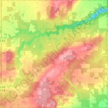
Name: Topografische Karte Town of Kelly, Höhe, Relief.
Ort: Town of Kelly, Bayfield County, Wisconsin, United States (46.41359 -91.05098 46.50225 -90.92442)
Durchschnittliche Höhe: 281 m
Minimale Höhe: 221 m
Maximale Höhe: 325 m
Andere topografische Karten
Klicken Sie auf eine Karte, um ihre Topografie, ihre Höhe und ihr Relief anzuzeigen.
Raspberry Island
United States > Wisconsin > Bayfield County
Raspberry Island, Town of Russell, Bayfield County, Wisconsin, United States
Durchschnittliche Höhe: 182 m
Houghton Point
United States > Wisconsin > Bayfield County
Houghton Point, Town of Bayview, Bayfield County, Wisconsin, United States
Durchschnittliche Höhe: 192 m
Town of Namakagon
United States > Wisconsin > Bayfield County
Town of Namakagon, Bayfield County, Wisconsin, United States
Durchschnittliche Höhe: 443 m
Sand Bay
United States > Wisconsin > Bayfield County > Sand Bay
Sand Bay, Town of Russell, Bayfield County, Wisconsin, United States
Durchschnittliche Höhe: 209 m