
Topografische Karte Cerro Mariposa
Interaktive Karte
Klicken Sie auf die Karte, um die Höhe anzuzeigen.
Über diese Karte
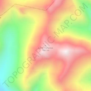
Name: Topografische Karte Cerro Mariposa, Höhe, Relief.
Durchschnittliche Höhe: 1.258 m
Minimale Höhe: 711 m
Maximale Höhe: 1.702 m
Andere topografische Karten
Klicken Sie auf eine Karte, um ihre Topografie, ihre Höhe und ihr Relief anzuzeigen.
Lago Largo
Chile > Región Aysén del General Carlos Ibáñez del Campo > Coyhaique > Lago Largo
Lago Largo, Coyhaique, Provincia de Coyhaique, Región Aysén del General Carlos Ibáñez del Campo, Chile
Durchschnittliche Höhe: 780 m
Volcán Hudson
Chile > Región Aysén del General Carlos Ibáñez del Campo > Coyhaique
Volcán Hudson, Coyhaique, Provincia de Coyhaique, Región Aysén del General Carlos Ibáñez del Campo, Chile
Durchschnittliche Höhe: 1.431 m
Reserva Nacional Trapananda
Chile > Región Aysén del General Carlos Ibáñez del Campo > Coyhaique
Reserva Nacional Trapananda, Cruce Ruta 7 (Villa Ortega) - Ñirehuao - Paso Pampa Alta, Mano Negra, Coyhaique, Provincia de Coyhaique, Región Aysén del General Carlos Ibáñez del Campo, Chile
Durchschnittliche Höhe: 1.034 m