
Topografische Karte Burnsville Lake
Interaktive Karte
Klicken Sie auf die Karte, um die Höhe anzuzeigen.
Über diese Karte
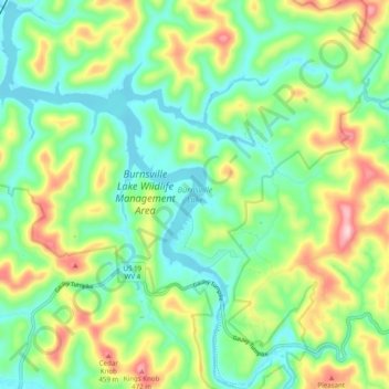
Name: Topografische Karte Burnsville Lake, Höhe, Relief.
Durchschnittliche Höhe: 318 m
Minimale Höhe: 233 m
Maximale Höhe: 485 m
Construction of the Burnsville Lake project was begun in the summer of 1972 and the dam was completed in September 1976. The lake project controls the runoff from a drainage area of 165 square miles (427 km²). The dam is a rock-fill embankment dam rising 84.5 feet (25.8 m) above the streambed. Top elevation is 839 feet (256 m) above sea level, and the crest length is 1,400 feet (430 m). A gated spillway is located in the left abutment. The outlet works are located in the spillway section. The minimum pool is maintained at elevation 776 feet (237 m) with a surface area of 550 acres (223 ha). The summer pool is at elevation 789 feet (240 m) and has a surface area of 968 acres (392 ha). The flood control pool is at elevation 825 feet (251 m) with a surface area of 1,900 acres (769 ha).
Andere topografische Karten
Klicken Sie auf eine Karte, um ihre Topografie, ihre Höhe und ihr Relief anzuzeigen.
Frametown
United States > West Virginia > Braxton County
Frametown, Braxton County, West Virginia, 26623, United States
Durchschnittliche Höhe: 307 m
Heaters
United States > West Virginia > Braxton County
Heaters, Braxton County, West Virginia, 26627, United States
Durchschnittliche Höhe: 324 m
Rosedale
United States > West Virginia > Braxton County
Rosedale, Braxton County, West Virginia, 26636, United States
Durchschnittliche Höhe: 317 m
Orlando
United States > West Virginia > Braxton County
Orlando, Braxton County, West Virginia, 26412, United States
Durchschnittliche Höhe: 322 m
Burnsville
United States > West Virginia > Braxton County
Burnsville, Braxton County, West Virginia, 26335, United States
Durchschnittliche Höhe: 295 m
Napier
United States > West Virginia > Braxton County
Napier, Braxton County, West Virginia, 26631, United States
Durchschnittliche Höhe: 317 m
Copen
United States > West Virginia > Braxton County
Copen, Braxton County, West Virginia, 26615, United States
Durchschnittliche Höhe: 334 m
Sutton
United States > West Virginia > Braxton County
Sutton, Braxton County, West Virginia, United States
Durchschnittliche Höhe: 320 m
Gassaway
United States > West Virginia > Braxton County
Gassaway, Braxton County, West Virginia, 26624, United States
Durchschnittliche Höhe: 318 m
Flatwoods
United States > West Virginia > Braxton County
Flatwoods, Braxton County, West Virginia, United States
Durchschnittliche Höhe: 364 m
Dutch
United States > West Virginia > Braxton County > Dutch
Dutch, Braxton County, West Virginia, 26627, United States
Durchschnittliche Höhe: 328 m
Little Birch
United States > West Virginia > Braxton County > Little Birch
Little Birch, Braxton County, West Virginia, 26629, United States
Durchschnittliche Höhe: 440 m