
Spenden
Rüsten Sie sich für Ihr nächstes Abenteuer:
Als Amazon-Partner erhält diese Website eine Provision für qualifizierte Käufe, ohne zusätzliche Kosten für Sie.
Topografische Karte Mount Fernie Provincial Park
Klicken Sie auf die Karte, um die Höhe anzuzeigen.
Spenden
Rüsten Sie sich für Ihr nächstes Abenteuer:
Als Amazon-Partner erhält diese Website eine Provision für qualifizierte Käufe, ohne zusätzliche Kosten für Sie.
Über diese Karte
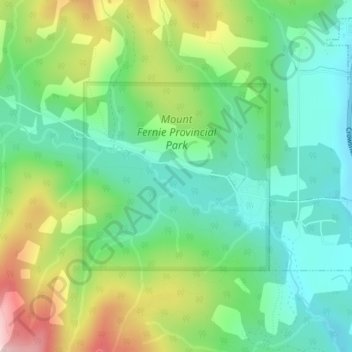
Name: Topografische Karte Mount Fernie Provincial Park, Höhe, Relief.
Durchschnittliche Höhe: 1.108 m
Minimale Höhe: 993 m
Maximale Höhe: 1.336 m
Spenden
Rüsten Sie sich für Ihr nächstes Abenteuer:
Als Amazon-Partner erhält diese Website eine Provision für qualifizierte Käufe, ohne zusätzliche Kosten für Sie.
Andere topografische Karten
Klicken Sie auf eine Karte, um ihre Topografie, ihre Höhe und ihr Relief anzuzeigen.
Upper Elk Lake
Canada > British Columbia > Regional District of East Kootenay > Area A (Upper Flathead/Elk Valley)
Durchschnittliche Höhe: 1.982 m
Grizzly Peak
Canada > British Columbia > Regional District of East Kootenay > Area A (Upper Flathead/Elk Valley)
Durchschnittliche Höhe: 1.962 m
Morrissey Provincial Park
Canada > British Columbia > Regional District of East Kootenay > Area A (Upper Flathead/Elk Valley)
Durchschnittliche Höhe: 1.040 m
Barnes Lake
Canada > British Columbia > Regional District of East Kootenay > Area A (Upper Flathead/Elk Valley)
Durchschnittliche Höhe: 2.073 m
Spenden
Rüsten Sie sich für Ihr nächstes Abenteuer:
Als Amazon-Partner erhält diese Website eine Provision für qualifizierte Käufe, ohne zusätzliche Kosten für Sie.
Tent Mountain
Canada > British Columbia > Regional District of East Kootenay > Area A (Upper Flathead/Elk Valley)
Durchschnittliche Höhe: 1.873 m
Rocky Mountains
Canada > British Columbia > Regional District of East Kootenay > Area A (Upper Flathead/Elk Valley)
Durchschnittliche Höhe: 2.159 m
Mount Fernie
Canada > British Columbia > Regional District of East Kootenay > Area A (Upper Flathead/Elk Valley)
Durchschnittliche Höhe: 1.804 m
Grave Lake
Canada > British Columbia > Regional District of East Kootenay > Area A (Upper Flathead/Elk Valley)
Durchschnittliche Höhe: 1.426 m
Spenden
Rüsten Sie sich für Ihr nächstes Abenteuer:
Als Amazon-Partner erhält diese Website eine Provision für qualifizierte Käufe, ohne zusätzliche Kosten für Sie.
Mount Strachan
Canada > British Columbia > Regional District of East Kootenay > Area A (Upper Flathead/Elk Valley)
Durchschnittliche Höhe: 2.198 m
Mount Erickson
Canada > British Columbia > Regional District of East Kootenay > Area A (Upper Flathead/Elk Valley)
Durchschnittliche Höhe: 1.938 m
Rocky Mountains
Canada > British Columbia > Regional District of East Kootenay > Area A (Upper Flathead/Elk Valley)
Durchschnittliche Höhe: 2.159 m
Mount Strachan
Canada > British Columbia > Regional District of East Kootenay > Area A (Upper Flathead/Elk Valley)
Durchschnittliche Höhe: 2.198 m
Spenden
Rüsten Sie sich für Ihr nächstes Abenteuer:
Als Amazon-Partner erhält diese Website eine Provision für qualifizierte Käufe, ohne zusätzliche Kosten für Sie.