
Topografische Karte Homs District
Interaktive Karte
Klicken Sie auf die Karte, um die Höhe anzuzeigen.
Über diese Karte
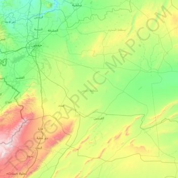
Name: Topografische Karte Homs District, Höhe, Relief.
Ort: Homs District, Homs Governorate, Syria (33.92629 36.27305 34.92539 37.76716)
Durchschnittliche Höhe: 836 m
Minimale Höhe: 296 m
Maximale Höhe: 2.587 m
Andere topografische Karten
Klicken Sie auf eine Karte, um ihre Topografie, ihre Höhe und ihr Relief anzuzeigen.
Al Hawz
Al Hawz, Al-Qusayr Subdistrict, Al-Qusayr District, Homs Governorate, Syria
Durchschnittliche Höhe: 503 m
Shaman
Shaman, Jubb Al-Jarah Subdistrict, Al-Mukharram District, Homs Governorate, Syria
Durchschnittliche Höhe: 953 m
Al Qusayr
Syria > Homs Governorate > Al Qusayr
Al Qusayr, Al-Qusayr Subdistrict, Al-Qusayr District, Homs Governorate, Syria
Durchschnittliche Höhe: 540 m
Homs
Syria > Homs Governorate > Homs
Homs, Homs Subdistrict, Homs District, Homs Governorate, 45151, Syria
Durchschnittliche Höhe: 533 m