
Spenden
Rüsten Sie sich für Ihr nächstes Abenteuer:
Als Amazon-Partner erhält diese Website eine Provision für qualifizierte Käufe, ohne zusätzliche Kosten für Sie.
Topografische Karte Bob Mountain
Klicken Sie auf die Karte, um die Höhe anzuzeigen.
Spenden
Rüsten Sie sich für Ihr nächstes Abenteuer:
Als Amazon-Partner erhält diese Website eine Provision für qualifizierte Käufe, ohne zusätzliche Kosten für Sie.
Über diese Karte
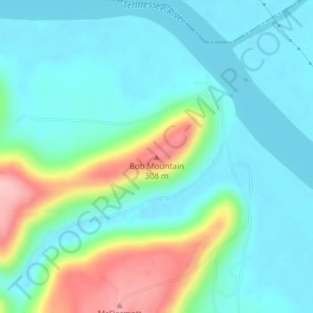
Name: Topografische Karte Bob Mountain, Höhe, Relief.
Ort: Bob Mountain, Marshall County, Alabama, United States (34.46671 -86.47504 34.46681 -86.47494)
Durchschnittliche Höhe: 206 m
Minimale Höhe: 167 m
Maximale Höhe: 324 m
Spenden
Rüsten Sie sich für Ihr nächstes Abenteuer:
Als Amazon-Partner erhält diese Website eine Provision für qualifizierte Käufe, ohne zusätzliche Kosten für Sie.
Andere topografische Karten
Klicken Sie auf eine Karte, um ihre Topografie, ihre Höhe und ihr Relief anzuzeigen.
Union Grove
United States > Alabama > Marshall County
Union Grove is located in western Marshall County at 34°24′0″N 86°26′46″W / 34.40000°N 86.44611°W / 34.40000; -86.44611 (34.400088, -86.446049). It is 7 miles (11 km) northeast of Arab and 5 miles (8 km) southwest of Guntersville Dam on the Tennessee River. Union Grove sits at an elevation…
Durchschnittliche Höhe: 304 m
Lake Guntersville State Park
United States > Alabama > Marshall County > Guntersville
Durchschnittliche Höhe: 242 m
Spenden
Rüsten Sie sich für Ihr nächstes Abenteuer:
Als Amazon-Partner erhält diese Website eine Provision für qualifizierte Käufe, ohne zusätzliche Kosten für Sie.
Grant
United States > Alabama > Marshall County
Grant is located in northeastern Marshall County at an elevation of 1,240 feet (380 m) on the plateau of Gunters Mountain. The town is concentrated along County Road 5 (Cathedral Caverns Highway, signed as Main Street in Grant) near the northern edge of Gunters Mountain, though the town includes corridors…
Durchschnittliche Höhe: 300 m
Union Grove
United States > Alabama > Marshall County
Union Grove is located in western Marshall County at 34°24′0″N 86°26′46″W / 34.40000°N 86.44611°W / 34.40000; -86.44611 (34.400088, -86.446049). It is 7 miles (11 km) northeast of Arab and 5 miles (8 km) southwest of Guntersville Dam on the Tennessee River. Union Grove sits at an elevation…
Durchschnittliche Höhe: 299 m