
Topografische Karte Bennachie
Interaktive Karte
Klicken Sie auf die Karte, um die Höhe anzuzeigen.
Über diese Karte
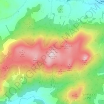
Name: Topografische Karte Bennachie, Höhe, Relief.
Ort: Bennachie, Auchleven, Aberdeenshire, Scotland, United Kingdom (57.28142 -2.61815 57.30704 -2.51634)
Durchschnittliche Höhe: 262 m
Minimale Höhe: 84 m
Maximale Höhe: 516 m
Mither Tap has an astronomical alignment with the nearby Pictish Fortalice of Caskieben (currently located within Keith Hall). Dr. Arthur Johnston said "the hill of Benochie, a conical elevation about eight miles distant, casts its shadow over Caskieben at the periods of the equinox."