
Topografische Karte Le Maraval
Interaktive Karte
Klicken Sie auf die Karte, um die Höhe anzuzeigen.
Über diese Karte
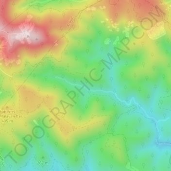
Name: Topografische Karte Le Maraval, Höhe, Relief.
Durchschnittliche Höhe: 313 m
Minimale Höhe: 114 m
Maximale Höhe: 591 m
Andere topografische Karten
Klicken Sie auf eine Karte, um ihre Topografie, ihre Höhe und ihr Relief anzuzeigen.
Cap Dramont
France > Provence-Alpes-Côte d'Azur > Saint-Raphaël
Cap Dramont, Saint-Raphaël, Draguignan, Var, Provence-Alpes-Côte d'Azur, France métropolitaine, 83530, France
Durchschnittliche Höhe: 42 m
Le Lion de Terre
France > Provence-Alpes-Côte d'Azur > Saint-Raphaël
Le Lion de Terre, Saint-Raphaël, Draguignan, Var, Provence-Alpes-Côte d'Azur, France métropolitaine, France
Durchschnittliche Höhe: 6 m
Pointe de l’Observatoire
France > Provence-Alpes-Côte d'Azur > Saint-Raphaël > Anthéor
Pointe de l’Observatoire, Route du Trayas, Anthéor, Saint-Raphaël, Draguignan, Var, Provence-Alpes-Côte d'Azur, France métropolitaine, 83530, France
Durchschnittliche Höhe: 52 m
Plage de Camp-Long
France > Provence-Alpes-Côte d'Azur > Saint-Raphaël > Le Dramont
Plage de Camp-Long, Rue Marie-Louise Robinson, Camp Long, Le Dramont, Saint-Raphaël, Draguignan, Var, Provence-Alpes-Côte d'Azur, France métropolitaine, 83530, France
Durchschnittliche Höhe: 19 m
Pic du Cap Roux
France > Provence-Alpes-Côte d'Azur > Saint-Raphaël
Pic du Cap Roux, Saint-Raphaël, Draguignan, Var, Provence-Alpes-Côte d'Azur, France métropolitaine, France
Durchschnittliche Höhe: 133 m
Rocher de Saint-Barthélemy
France > Provence-Alpes-Côte d'Azur > Saint-Raphaël
Rocher de Saint-Barthélemy, D 559, Agay, Saint-Raphaël, Draguignan, Var, Provence-Alpes-Côte d'Azur, France métropolitaine, 83530, France
Durchschnittliche Höhe: 99 m
Baisse de la grosse vache
France > Provence-Alpes-Côte d'Azur > Saint-Raphaël
Baisse de la grosse vache, Piste du Ravin du Mal Infernet, Agay, Saint-Raphaël, Draguignan, Var, Provence-Alpes-Côte d'Azur, France métropolitaine, 83530, France
Durchschnittliche Höhe: 173 m