
Topografische Karte Marshall
Interaktive Karte
Klicken Sie auf die Karte, um die Höhe anzuzeigen.
Über diese Karte
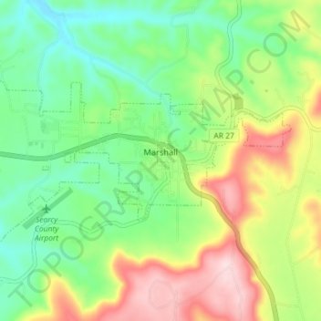
Name: Topografische Karte Marshall, Höhe, Relief.
Ort: Marshall, Searcy County, Arkansas, 72650, United States (35.89277 -92.67378 35.92193 -92.60221)
Durchschnittliche Höhe: 331 m
Minimale Höhe: 226 m
Maximale Höhe: 503 m
For bicycling, the Ozark Grinder Trail is a nearby gravel grinder bicycle trail covering approximately 200 miles and 13,000 feet of elevation in north central Arkansas Ozarks. The annual Arkansaw High Country Race transits through Marshall each June. This event is an approximately 1,034-mile self-supported (bikepacking) gravel cycling race with approximately 84,000 feet of total elevation.
Andere topografische Karten
Klicken Sie auf eine Karte, um ihre Topografie, ihre Höhe und ihr Relief anzuzeigen.
Lead Hill
United States > Arkansas > Searcy County
Lead Hill, Searcy County, Arkansas, United States
Durchschnittliche Höhe: 286 m
Saint Joe
United States > Arkansas > Searcy County
Saint Joe, Searcy County, Arkansas, 72675, United States
Durchschnittliche Höhe: 260 m
Gilbert
United States > Arkansas > Searcy County
Gilbert, Searcy County, Arkansas, 72636, United States
Durchschnittliche Höhe: 216 m
Buffalo River
United States > Arkansas > Searcy County > Gilbert
Buffalo River, Gilbert, Searcy County, Arkansas, 72636, United States
Durchschnittliche Höhe: 217 m
Buffalo National River
United States > Arkansas > Searcy County
Buffalo National River, Searcy County, Arkansas, 72624, United States
Durchschnittliche Höhe: 444 m
Leslie
United States > Arkansas > Searcy County > Leslie > Leslie
Leslie, Searcy County, Arkansas, 72645, United States
Durchschnittliche Höhe: 347 m
Cozahome
United States > Arkansas > Searcy County > Cozahome
Cozahome, Searcy County, Arkansas, United States
Durchschnittliche Höhe: 307 m