
Topografische Karte Shah Mansur District
Interaktive Karte
Klicken Sie auf die Karte, um die Höhe anzuzeigen.
Über diese Karte
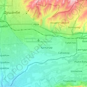
Name: Topografische Karte Shah Mansur District, Höhe, Relief.
Ort: Shah Mansur District, Dushanbe, 734000, Tajikistan (38.49418 68.76880 38.58933 68.88710)
Durchschnittliche Höhe: 807 m
Minimale Höhe: 724 m
Maximale Höhe: 1.049 m
Dushanbe (Tajik: Душанбе, IPA: [duʃæmˈbe]; Persian: دوشنبه, lit. 'Monday'; Russian: Душанбе) is the capital and largest city of Tajikistan. As of January 2022, Dushanbe had a population of 1,201,800 and that population was largely Tajik. Until 1929, the city was known in Russian as Dyushambe (Russian: Дюшамбе, Dyushambe), and from 1929 to 1961 as Stalinabad (Tajik: Сталинобод, romanized: Stalinobod), after Joseph Stalin. Dushanbe is located in the Gissar Valley, bounded by the Gissar Range in the north and east and the Babatag, Aktau, Rangontau and Karatau mountains in the south, and has an elevation of 750–930 m. The city is divided into four districts, all named after Persian historical figures: Ismail Samani, Avicenna, Ferdowsi, and Shah Mansur.