
Topografische Karte Casale Monferrato
Interaktive Karte
Klicken Sie auf die Karte, um die Höhe anzuzeigen.
Casale Monferrato
At the south-east corner of the piazza is the elegant Baroque church of Santa Maria delle Grazie, better known by its earlier designation of Santa Caterina. A master-work of Giovanni Battista Scapitta, completed after his death by Giacomo Zanetti, it is marked by an elliptical cupola, and a façade curvilinear both in plan and elevation.
Über diese Karte
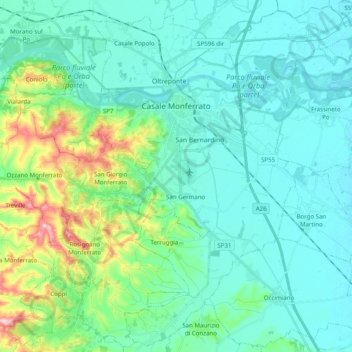
Name: Topografische Karte Casale Monferrato, Höhe, Relief.
Ort: Casale Monferrato, Alessandria, Piedmont, 15033, Italy (45.04102 8.35945 45.17566 8.55704)
Durchschnittliche Höhe: 142 m
Minimale Höhe: 97 m
Maximale Höhe: 338 m
Andere topografische Karten
Klicken Sie auf eine Karte, um ihre Topografie, ihre Höhe und ihr Relief anzuzeigen.
Silver poplar
Italy > Piedmont > Alessandria > Castelnuovo Scrivia > Il Secco
Durchschnittliche Höhe: 79 m