
Topografische Karte Châteauvieux
Interaktive Karte
Klicken Sie auf die Karte, um die Höhe anzuzeigen.
Über diese Karte
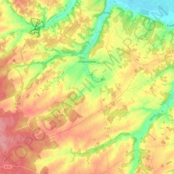
Name: Topografische Karte Châteauvieux, Höhe, Relief.
Durchschnittliche Höhe: 123 m
Minimale Höhe: 69 m
Maximale Höhe: 164 m
L'altitude du territoire communal varie de 79 mètres à 160 mètres.
Andere topografische Karten
Klicken Sie auf eine Karte, um ihre Topografie, ihre Höhe und ihr Relief anzuzeigen.
Le Petit Four
France > Centre-Val de Loire > Loir-et-Cher > Saint-Laurent-Nouan
Le Petit Four, Saint-Laurent-Nouan, Blois, Loir-et-Cher, Centre-Val de Loire, France métropolitaine, 41220, France
Durchschnittliche Höhe: 87 m
Le Boêl
France > Centre-Val de Loire > Loir-et-Cher > Nourray
Le Boêl, Nourray, Vendôme, Loir-et-Cher, Centre-Val de Loire, France métropolitaine, 41310, France
Durchschnittliche Höhe: 125 m
Les Rocheuses
France > Centre-Val de Loire > Loir-et-Cher > Villiers-sur-Loir
Les Rocheuses, Villiers-sur-Loir, Vendôme, Loir-et-Cher, Centre-Val de Loire, France métropolitaine, 41100, France
Durchschnittliche Höhe: 95 m
Le Marchais Fournier
France > Centre-Val de Loire > Loir-et-Cher > Sambin
Le Marchais Fournier, Sambin, Blois, Loir-et-Cher, Centre-Val de Loire, France métropolitaine, 41120, France
Durchschnittliche Höhe: 109 m
Vouzon
France > Centre-Val de Loire > Loir-et-Cher
Vouzon, Romorantin-Lanthenay, Loir-et-Cher, Centre-Val de Loire, France métropolitaine, 41600, France
Durchschnittliche Höhe: 126 m
Nouan-le-Fuzelier
France > Centre-Val de Loire > Loir-et-Cher > Nouan-le-Fuzelier
Nouan-le-Fuzelier, Romorantin-Lanthenay, Loir-et-Cher, Centre-Val de Loire, France métropolitaine, 41600, France
Durchschnittliche Höhe: 119 m
Beauce la Romaine
France > Centre-Val de Loire > Loir-et-Cher > Beauce la Romaine
Beauce la Romaine, Blois, Loir-et-Cher, Centre-Val de Loire, France métropolitaine, France
Durchschnittliche Höhe: 128 m
Blois
France > Centre-Val de Loire > Loir-et-Cher
Blois, Loir-et-Cher, Centre-Val de Loire, France métropolitaine, 41000, France
Durchschnittliche Höhe: 95 m