
Topografische Karte Fondeado Island
Interaktive Karte
Klicken Sie auf die Karte, um die Höhe anzuzeigen.
Über diese Karte
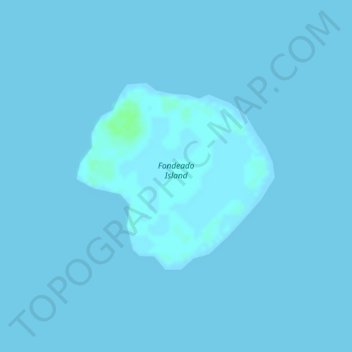
Name: Topografische Karte Fondeado Island, Höhe, Relief.
Ort: Fondeado Island, Puerto Princesa, Mimaropa, 5300, Philippines (9.92614 118.91720 9.94047 118.93265)
Durchschnittliche Höhe: 0 m
Minimale Höhe: 0 m
Maximale Höhe: 7 m
Andere topografische Karten
Klicken Sie auf eine Karte, um ihre Topografie, ihre Höhe und ihr Relief anzuzeigen.
Tres Marias Islands
Philippines > Mimaropa > Puerto Princesa
Tres Marias Islands, Puerto Princesa, Mimaropa, 5300, Philippines
Durchschnittliche Höhe: 74 m
Parunponon Island
Philippines > Mimaropa > Puerto Princesa
Parunponon Island, Puerto Princesa, Mimaropa, 5300, Philippines
Durchschnittliche Höhe: 0 m
Kalungpang Island
Philippines > Mimaropa > Puerto Princesa
Kalungpang Island, Puerto Princesa, Mimaropa, 5300, Philippines
Durchschnittliche Höhe: 0 m
Meara Island
Philippines > Mimaropa > Puerto Princesa
Meara Island, Puerto Princesa, Mimaropa, 5300, Philippines
Durchschnittliche Höhe: 0 m
Cleopatra Needle
Philippines > Mimaropa > Puerto Princesa
Cleopatra Needle, Puerto Princesa, Mimaropa, 5300, Philippines
Durchschnittliche Höhe: 1.014 m
Hen and Chickens Islands
Philippines > Mimaropa > Puerto Princesa
Hen and Chickens Islands, Puerto Princesa, Mimaropa, 5300, Philippines
Durchschnittliche Höhe: 51 m
Makesi Island
Philippines > Mimaropa > Puerto Princesa
Makesi Island, Puerto Princesa, Mimaropa, 5300, Philippines
Durchschnittliche Höhe: 0 m