
Topografische Karte Whakamarama
Interaktive Karte
Klicken Sie auf die Karte, um die Höhe anzuzeigen.
Über diese Karte
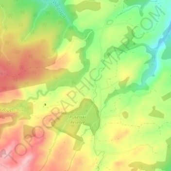
Name: Topografische Karte Whakamarama, Höhe, Relief.
Durchschnittliche Höhe: 266 m
Minimale Höhe: 180 m
Maximale Höhe: 345 m
Andere topografische Karten
Klicken Sie auf eine Karte, um ihre Topografie, ihre Höhe und ihr Relief anzuzeigen.
Tauranga City
Nouvelle-Zélande > Bay of Plenty
Tauranga City, Bay of Plenty, Nouvelle-Zélande
Durchschnittliche Höhe: 55 m
Rotorua Lakes District
Nouvelle-Zélande > Bay of Plenty
Rotorua Lakes District, Bay of Plenty, Nouvelle-Zélande
Durchschnittliche Höhe: 404 m
Wairere Falls
Nouvelle-Zélande > Bay of Plenty > Rotorua
Wairere Falls, Rotorua, Rotorua District, Bay of Plenty, Nouvelle-Zélande
Durchschnittliche Höhe: 451 m
Mayor Island / Tuhua
Nouvelle-Zélande > Bay of Plenty > Tauranga
Mayor Island / Tuhua, Tauranga, Bay of Plenty, Nouvelle-Zélande
Durchschnittliche Höhe: 71 m
Lake Ōkataina
Nouvelle-Zélande > Bay of Plenty > Ruato
Lake Ōkataina, Eastern Okataina Walkway, Ruato, Rotorua District, Bay of Plenty, Nouvelle-Zélande
Durchschnittliche Höhe: 440 m
Whakatāne District
Nouvelle-Zélande > Bay of Plenty
Whakatāne District, Bay of Plenty, Nouvelle-Zélande
Durchschnittliche Höhe: 416 m
Rotorua
Nouvelle-Zélande > Bay of Plenty > Rotorua Lakes District
Rotorua, Rotorua Lakes District, Bay of Plenty, 3010, Nouvelle-Zélande
Durchschnittliche Höhe: 435 m